IMAGES TAKEN NEAR TO
Barn Lane, HIGH WYCOMBE, HP15 7DQ
Introduction
This page details the photographs taken nearby to Barn Lane, HP15 7DQ by members of the Geograph project.
The Geograph project started in 2005 with the aim of publishing, organising and preserving representative images for every square kilometre of Great Britain, Ireland and the Isle of Man.

There are currently over 7.5m images from over14,400 individuals and you can help contribute to the project by visiting https://www.geograph.org.uk
Image Map (Loading...)


Getting Data...Please wait
Leaflet Map data © OpenStreetMap
Images are licensed for reuse under creativecommons.org/licenses/by-sa/2.0
Notes
- Clicking on the map will re-center to the selected point.
- The higher the marker number, the further away the image location is from the centre of the postcode.
Image Listing (5 Images Found)
Images are licensed for reuse under creativecommons.org/licenses/by-sa/2.0
Image
Details
Distance
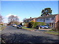
2
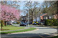
Cedar Avenue, Hazlemere
Some of the leafy suburbia to the north of High Wycombe.
Image: © Andrew Smith
Taken: 2 Apr 2023
0.16 miles
3
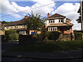
Houses on Holmer Green Road, Hazlemere
Image: © David Howard
Taken: 10 Aug 2017
0.22 miles
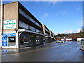
5
Cedar Avenue, Hazlemere
Typical of the suburban sprawl to the north of Wycombe.
Image: © Andrew Smith
Taken: 2 Apr 2006
0.23 miles