IMAGES TAKEN NEAR TO
Rossetti Place, HIGH WYCOMBE, HP15 6XA
Introduction
This page details the photographs taken nearby to Rossetti Place, HP15 6XA by members of the Geograph project.
The Geograph project started in 2005 with the aim of publishing, organising and preserving representative images for every square kilometre of Great Britain, Ireland and the Isle of Man.

There are currently over 7.5m images from over14,400 individuals and you can help contribute to the project by visiting https://www.geograph.org.uk
Image Map (Loading...)


Getting Data...Please wait
Leaflet Map data © OpenStreetMap
Images are licensed for reuse under creativecommons.org/licenses/by-sa/2.0
Notes
- Clicking on the map will re-center to the selected point.
- The higher the marker number, the further away the image location is from the centre of the postcode.
Image Listing (34 Images Found)
Images are licensed for reuse under creativecommons.org/licenses/by-sa/2.0
Image
Details
Distance
1
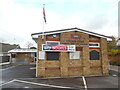
Royal British Legion Hall at Holmer Green
Located at 48 Beech Tree Road HP15 6UT, this hall dates from 2009 as indicated on the top of the building, although it was probably rebuilt before that year. The entrance to the hall can be seen to the left of the photo whilst a Union Jack flag is on a pole at the front.
Image: © David Hillas
Taken: 3 Nov 2020
0.05 miles
2
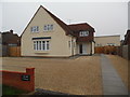
The Old Exchange, Holmer Green
Situated in New Pond Road HP15 6SU, this building used to be a wholesale book store, but has been refurbished and now comprises of five apartments http://www.geograph.org.uk/photo/1074615 refers. Previously, it was Holmer Green Telephone Exchange until it was replaced by the current TE in Primrose Hill, Widmer End in the early 1970s http://www.geograph.org.uk/photo/1074621 refers. The television aerial on its roof is directed towards the TV transmitter at Crystal Palace in South London, TQ3371 refers. The name "The Old Exchange" can be seen on the brick wall to the left of the photo.
Image: © David Hillas
Taken: 6 Nov 2018
0.08 miles
3
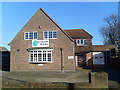
Former Telephone Exchange, Holmer Green
Situated in New Pond Road, Holmer Green, HP15 6SU, this former TE is now a wholesale book store. It was replaced in the early 1970s by the TE off Primrose Hill, Widmer End, SU8897 refers http://www.geograph.org.uk/photo/1074621. Update: this former TE has recently been converted into five apartments, the name being "The Old Exchange" http://www.geograph.org.uk/photo/5968872 refers.
Image: © David Hillas
Taken: 6 Dec 2008
0.09 miles
4
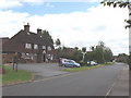
The Old Oak Inn, Holmer Green
Holmer Green is an old village, but has many modern houses
Image: © David Hawgood
Taken: 17 Jun 2005
0.10 miles
5
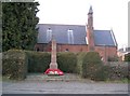
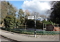
Holmer Green: The War Memorial
This simple stone, on the north side of Beech Tree Road in front of Christ Church, commemorates 14 Holmer Green men who gave their lives during conflicts.
Image: © Nigel Cox
Taken: 10 Feb 2008
0.10 miles
6

The Village Centre, Holmer Green
Situated on the north side of The Common, HP15 6XG, this village hall is hired out to various organisations in the area. To the left of the centre below "The Village Centre" board, can be seen a poster for the Holmer Green Village Centre Pre-School. On the extreme right of the photo is the village centre noticeboard whilst the car park is in the foreground.
Image: © David Hillas
Taken: 25 Jan 2019
0.12 miles
7
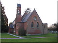
Holmer Green: Christ Church
Built in 1894, the church is in the parish of Penn Street with Holmer Green, and is on the north side of Beech Tree Road. There is a solitary bell in the tower.
Image: © Nigel Cox
Taken: 10 Feb 2008
0.12 miles
9
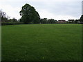
Village Green, Holmer Green
Used as a recreation ground.
Image: © David Purchase
Taken: 9 Apr 2015
0.14 miles
10
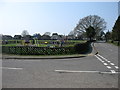
Pond on the Corner, Holmer Green
Village pond by the crossroads.
Image: © Des Blenkinsopp
Taken: 7 Mar 2018
0.16 miles