IMAGES TAKEN NEAR TO
Glebe Close, HIGH WYCOMBE, HP15 6UY
Introduction
This page details the photographs taken nearby to Glebe Close, HP15 6UY by members of the Geograph project.
The Geograph project started in 2005 with the aim of publishing, organising and preserving representative images for every square kilometre of Great Britain, Ireland and the Isle of Man.

There are currently over 7.5m images from over14,400 individuals and you can help contribute to the project by visiting https://www.geograph.org.uk
Image Map
Images are licensed for reuse under creativecommons.org/licenses/by-sa/2.0
Notes
- Clicking on the map will re-center to the selected point.
- The higher the marker number, the further away the image location is from the centre of the postcode.
Image Listing (7 Images Found)
Images are licensed for reuse under creativecommons.org/licenses/by-sa/2.0
Image
Details
Distance
2
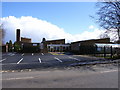
Holmer Green First School
Backed by a cumulus which had a little earlier delivered a squally shower.
Image: © Andrew Smith
Taken: 2 Apr 2006
0.11 miles
3
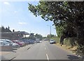
Beech Tree Road passes Beech Tree Autos
Image: © Stuart Logan
Taken: 30 Jul 2014
0.11 miles
4
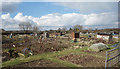
Allotments, Beech Tree Rd, Holmer Green
Image: © Des Blenkinsopp
Taken: 7 Mar 2018
0.12 miles
5
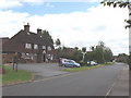
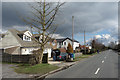
The Old Oak Inn, Holmer Green
Holmer Green is an old village, but has many modern houses
Image: © David Hawgood
Taken: 17 Jun 2005
0.16 miles
6
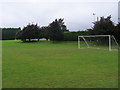
Holmer Green football club
Holmer Green football club off Watchet Lane
Image: © Shaun Ferguson
Taken: 7 Sep 2008
0.17 miles
7
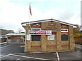
Royal British Legion Hall at Holmer Green
Located at 48 Beech Tree Road HP15 6UT, this hall dates from 2009 as indicated on the top of the building, although it was probably rebuilt before that year. The entrance to the hall can be seen to the left of the photo whilst a Union Jack flag is on a pole at the front.
Image: © David Hillas
Taken: 3 Nov 2020
0.24 miles