IMAGES TAKEN NEAR TO
Earl Howe Road, HIGH WYCOMBE, HP15 6QT
Introduction
This page details the photographs taken nearby to Earl Howe Road, HP15 6QT by members of the Geograph project.
The Geograph project started in 2005 with the aim of publishing, organising and preserving representative images for every square kilometre of Great Britain, Ireland and the Isle of Man.

There are currently over 7.5m images from over14,400 individuals and you can help contribute to the project by visiting https://www.geograph.org.uk
Image Map
Images are licensed for reuse under creativecommons.org/licenses/by-sa/2.0
Notes
- Clicking on the map will re-center to the selected point.
- The higher the marker number, the further away the image location is from the centre of the postcode.
Image Listing (14 Images Found)
Images are licensed for reuse under creativecommons.org/licenses/by-sa/2.0
Image
Details
Distance
1
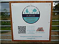
Entrance Board at Jubilee Sensory Garden, Holmer Green
This board is at the entrance to the Jubilee Sensory Garden in Earl Howe Road. These gardens are managed by the Holmer Green Village Society and further information can be obtained from its website "www.holmergreenvillagesociety.co.uk/jubileesensorygarden". At the foot of the board, it mentions that these gates access the Jubilee Sensory Garden and allotments only.
Image: © David Hillas
Taken: 25 Aug 2023
0.02 miles
2
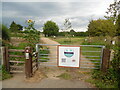
Jubilee Sensory Garden, Holmer Green
Situated in Earl Howe Road HP15 6QT. this sensory garden is managed by the Holmer Green Village Society and mentioned on its website as at https://www.holmergreenvillagesociety.co.uk/jubileesensorygarden. Work on this garden commenced in March 2021 and now comprises different sensory elements for the public to see, smell, hear and touch.
Image: © David Hillas
Taken: 25 Aug 2023
0.03 miles
3
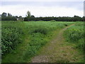
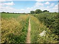
Footpath to the allotments
Footpath off Earl Howe Road to the allotments
Image: © Shaun Ferguson
Taken: 7 Sep 2008
0.10 miles
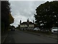
4
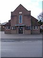
Methodist church, Holmer Green
Dated 1937.
Image: © Andrew Smith
Taken: 8 Apr 2006
0.14 miles
5
The entrance to Greenacres, Holmer Green
This was a caravan park but appears to have become a small housing estate.
Image: © David Howard
Taken: 8 Oct 2015
0.18 miles
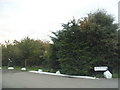
7
Navigating northwards up the Bashire (62)
Autumn in Earl Howe Road
Image: © Basher Eyre
Taken: 29 Oct 2024
0.18 miles
8
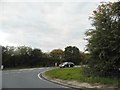
Earl Howe Road at the junction of Amersham Road
Image: © David Howard
Taken: 8 Oct 2015
0.22 miles
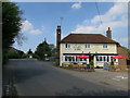
10
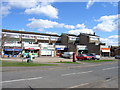
Shops in Holmer Green
Holmer Green is part of the suburban sprawl to the northeast of Wycombe.
Image: © Andrew Smith
Taken: 8 Apr 2006
0.23 miles