IMAGES TAKEN NEAR TO
Spurlands End Road, HIGH WYCOMBE, HP15 6HX
Introduction
This page details the photographs taken nearby to Spurlands End Road, HP15 6HX by members of the Geograph project.
The Geograph project started in 2005 with the aim of publishing, organising and preserving representative images for every square kilometre of Great Britain, Ireland and the Isle of Man.

There are currently over 7.5m images from over14,400 individuals and you can help contribute to the project by visiting https://www.geograph.org.uk
Image Map (Loading...)


Getting Data...Please wait
Leaflet Map data © OpenStreetMap
Images are licensed for reuse under creativecommons.org/licenses/by-sa/2.0
Notes
- Clicking on the map will re-center to the selected point.
- The higher the marker number, the further away the image location is from the centre of the postcode.
Image Listing (10 Images Found)
Images are licensed for reuse under creativecommons.org/licenses/by-sa/2.0
Image
Details
Distance
1
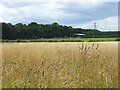
Grassland, Great Kingshill
Looking towards the buildings at the northern end of Birchmore Wood which aren't marked on the map.
Image: © Andrew Smith
Taken: 17 Aug 2008
0.12 miles
2
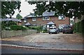
Houses on Heath End Road, Great Kingshill
Image: © David Howard
Taken: 11 Jun 2020
0.15 miles
5
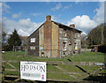
Derelict House, Heath End
Shortly to be renovated judging by the notice. It will fetch a tidy sum when it's done.
Image: © Des Blenkinsopp
Taken: 7 Mar 2018
0.17 miles
6

Label on top of decorated postbox, Heath End
This label is attached to the knitted crown on top of the post box in Heath End Road near St Margaret's Grove. It has the following wording:
Made with love
for our village
♥
GK Postbox Topper Ladies
Incidentally, GK stands for Great Kingshill which is adjacent to Heath End.
Image: © David Hillas
Taken: 4 May 2023
0.17 miles
7
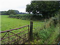
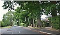
Footpath off Copes Lane
Footpath off Copes Lane by Cockpit Hole
Image: © Shaun Ferguson
Taken: 7 Sep 2008
0.17 miles
8
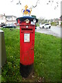
Decorated Post Box in Heath End
This Elizabeth II postbox is located in Heath End Road HP15 6HL and has a knitted crown on its top to commemorate the coronation of King Charles III on Saturday 6th May 2023. The wording on the label below the top is at https://www.geograph.org.uk/photo/7479279. St Margaret's Road can just be seen to the left of the postbox.
Image: © David Hillas
Taken: 6 May 2023
0.17 miles
9

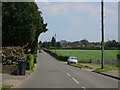
Spurlands End Road junction with Copes Road
Image: © Stuart Logan
Taken: 30 Jul 2014
0.17 miles
10
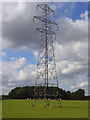
Pylon in pasture, Great Kingshill
Behind are the cattle and copse shown in Image
Image: © Andrew Smith
Taken: 17 Aug 2008
0.19 miles