IMAGES TAKEN NEAR TO
Fairfields, HIGH WYCOMBE, HP15 6EP
Introduction
This page details the photographs taken nearby to Fairfields, HP15 6EP by members of the Geograph project.
The Geograph project started in 2005 with the aim of publishing, organising and preserving representative images for every square kilometre of Great Britain, Ireland and the Isle of Man.

There are currently over 7.5m images from over14,400 individuals and you can help contribute to the project by visiting https://www.geograph.org.uk
Image Map (Loading...)


Getting Data...Please wait
Leaflet Map data © OpenStreetMap
Images are licensed for reuse under creativecommons.org/licenses/by-sa/2.0
Notes
- Clicking on the map will re-center to the selected point.
- The higher the marker number, the further away the image location is from the centre of the postcode.
Image Listing (20 Images Found)
Images are licensed for reuse under creativecommons.org/licenses/by-sa/2.0
Image
Details
Distance
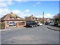
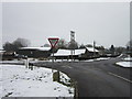
1
Heath End Road, Great Kingshill
Looking north from the crossroads by the pond.
Image: © Andrew Smith
Taken: 2 Apr 2006
0.05 miles
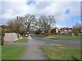
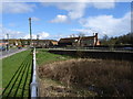
2
Fairfields, Great Kingshill
A small cul-de-sac of bungalows and houses.
Image: © Andrew Smith
Taken: 2 Apr 2006
0.05 miles
3
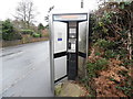
Former KX300 Telephone Kiosk, Great Kingshill
Situated in Stag Lane HP15 6EW, this telephone kiosk has a BT notice on its left indicating that this kiosk will shortly be removed due to lack of usage. Update: this telephone kiosk has since been taken out.
Image: © David Hillas
Taken: 23 Dec 2016
0.07 miles
4
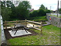
Seating at Cockpit Hole
Cockpit Hole is surrounded by a metal fence as it is deep and a lot larger than it first looks. In 2008 the hole was spruced up with access provided by steps to wooden walkways and viewing areas above and around a pond. Whether or not it has been stocked with fish I could not see. The origin of the hole is somewhat sketchy, but one explanation below comes from the "Geological Sites" section of the Prestwood Nature website.
"Swallow-holes occur most commonly in the hard limestones on the north and west of Britain, but similar phenomena occasionally manifest themselves in the chalk regions. They occur where underground water has worn channels through the chalk and the chalk above them has gradually weathered away, suddenly giving way so that the overlaying clay falls into a huge hole. These swallow-holes can be differentiated from quarries by the fact that their sides are steep all the way round, ie there is no graded access to cart out excavated material. A good example can be seen near the north edge of Atkins Wood. The large depression known as Cockpit Hole in Great Kingshill may also have had its origin in this way, as it is too deep and steep-sided to have ever been useful as a pond, and (contrary to legend) was never used as pit for cock-fighting."
Image: © Sean Davis
Taken: 22 May 2009
0.09 miles
5
Cockpit Hole at Great Kingshill
Cockpit Hole is surrounded by a metal fence as it is deep and a lot larger than it first looks. In 2008 the hole was spruced up with access provided by steps to wooden walkways and viewing areas above and around a pond. Whether or not it has been stocked with fish I could not see. The origin of the hole is somewhat sketchy, but one explanation below comes from the "Geological Sites" section of the Prestwood Nature website.
"Swallow-holes occur most commonly in the hard limestones on the north and west of Britain, but similar phenomena occasionally manifest themselves in the chalk regions. They occur where underground water has worn channels through the chalk and the chalk above them has gradually weathered away, suddenly giving way so that the overlaying clay falls into a huge hole. These swallow-holes can be differentiated from quarries by the fact that their sides are steep all the way round, ie there is no graded access to cart out excavated material. A good example can be seen near the north edge of Atkins Wood. The large depression known as Cockpit Hole in Great Kingshill may also have had its origin in this way, as it is too deep and steep-sided to have ever been useful as a pond, and (contrary to legend) was never used as pit for cock-fighting."
Image: © Sean Davis
Taken: 22 May 2009
0.09 miles
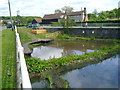
6
Cockpit Hole, Great Kingshill
An unusual pond well below street level, with a grassy slope at one end. I guess this would have been for animals to come down and drink in days gone by.
A notice on the wall says that the pond was restored in 2008.
It probably looks better in the summer without all the dead stuff in it.
Image: © Des Blenkinsopp
Taken: 7 Mar 2018
0.09 miles
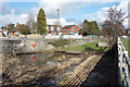
8
Pond and cottage, Great Kingshill
The quantity of water in the pond is symptomatic of the lack of rainfall in south-east England.
Image: © Andrew Smith
Taken: 2 Apr 2006
0.11 miles
9
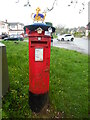
Decorated Post Box in Heath End
This Elizabeth II postbox is located in Heath End Road HP15 6HL and has a knitted crown on its top to commemorate the coronation of King Charles III on Saturday 6th May 2023. The wording on the label below the top is at https://www.geograph.org.uk/photo/7479279. St Margaret's Road can just be seen to the left of the postbox.
Image: © David Hillas
Taken: 6 May 2023
0.14 miles
10

Label on top of decorated postbox, Heath End
This label is attached to the knitted crown on top of the post box in Heath End Road near St Margaret's Grove. It has the following wording:
Made with love
for our village
♥
GK Postbox Topper Ladies
Incidentally, GK stands for Great Kingshill which is adjacent to Heath End.
Image: © David Hillas
Taken: 4 May 2023
0.14 miles