IMAGES TAKEN NEAR TO
Bottom Road, HIGH WYCOMBE, HP14 4EQ
Introduction
This page details the photographs taken nearby to Bottom Road, HP14 4EQ by members of the Geograph project.
The Geograph project started in 2005 with the aim of publishing, organising and preserving representative images for every square kilometre of Great Britain, Ireland and the Isle of Man.

There are currently over 7.5m images from over14,400 individuals and you can help contribute to the project by visiting https://www.geograph.org.uk
Image Map (Loading...)


Getting Data...Please wait
Leaflet Map data © OpenStreetMap
Images are licensed for reuse under creativecommons.org/licenses/by-sa/2.0
Notes
- Clicking on the map will re-center to the selected point.
- The higher the marker number, the further away the image location is from the centre of the postcode.
Image Listing (26 Images Found)
Images are licensed for reuse under creativecommons.org/licenses/by-sa/2.0
Image
Details
Distance
1
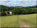
Footpath through wheat, Radnage
A well marked descent to Bottom Road. The mast is beyond Stokenchurch.
Image: © Andrew Smith
Taken: 13 Jul 2008
0.05 miles
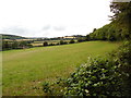
2
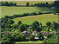
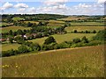
Houses and fields, Radnage
Looking down on houses on Bottom Lane and a farmhouse on Bowers Lane. Between are pastoral fields with sheep just discernible in the second.
Image: © Andrew Smith
Taken: 13 Jul 2008
0.05 miles
4
Wheat, Radnage
The crop growing in the relatively flat valley. Sheep can be seen grazing in a field beyond Bottom Road.
Image: © Andrew Smith
Taken: 13 Jul 2008
0.11 miles
5
Countryside, Radnage
Radnage is a somewhat scattered village and the houses here on Bottom Lane are remote from others in the valley further to the west and on the hilltop to the south. This is the view across the valley towards Stokenchurch from a small area of access land to the east of Yoesden Wood.
Image: © Andrew Smith
Taken: 13 Jul 2008
0.11 miles
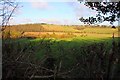
6
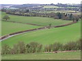
Farmland, Radnage
Looking down from a bridleway descending westwards from Bledlow ridge. This side of the valley is the more steep. It consists of arable farmland, pastures and woodland.
Image: © Andrew Smith
Taken: 3 Feb 2008
0.13 miles
7
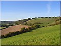
Countryside below Bledlow Ridge
A view of the western flank of the ridge and the valley containing Radnage from just above Bottom Road.
Image: © Andrew Smith
Taken: 11 Oct 2008
0.14 miles
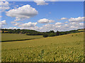
8
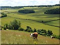
Farmland, Radnage
A cattle-grazed steep hillside with fields of wheat below either side of Bottom Road. This is the view from the eastern edge of a small area of access land.
Image: © Andrew Smith
Taken: 13 Jul 2008
0.14 miles
9
View from Yoesden Wood
This photo shows a view of fields looking westwards from Yoesden Wood towards Stokenchurch. The houses to the left of the photo are in Bottom Road.
Image: © David Hillas
Taken: 30 Jul 2016
0.15 miles
10

Hillside below Bledlow Ridge
The land in the foreground is access land. We are looking across a combe towards Yoesden Wood.
Image: © Andrew Smith
Taken: 13 Jul 2008
0.15 miles