IMAGES TAKEN NEAR TO
Stokenchurch, HIGH WYCOMBE, HP14 3YJ
Introduction
This page details the photographs taken nearby to HP14 3YJ by members of the Geograph project.
The Geograph project started in 2005 with the aim of publishing, organising and preserving representative images for every square kilometre of Great Britain, Ireland and the Isle of Man.

There are currently over 7.5m images from over14,400 individuals and you can help contribute to the project by visiting https://www.geograph.org.uk
Image Map
Images are licensed for reuse under creativecommons.org/licenses/by-sa/2.0
Notes
- Clicking on the map will re-center to the selected point.
- The higher the marker number, the further away the image location is from the centre of the postcode.
Image Listing (57 Images Found)
Images are licensed for reuse under creativecommons.org/licenses/by-sa/2.0
Image
Details
Distance
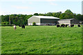
2
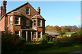
Hill Farm
Just off the A40. The house is in this square, the farm buildings are in Image
Image: © Graham Horn
Taken: 7 Nov 2010
0.05 miles
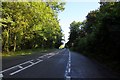
3
The A40 entering Oxfordshire
It is about to descend the Chiltern escarpment.
Image: © Bill Boaden
Taken: 10 May 2018
0.06 miles
5
Cattle by Hill Farm
On the plateau at the top of the Chilterns.
Image: © Bill Boaden
Taken: 10 May 2018
0.08 miles
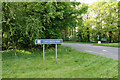
6

Junction with Aston Hill (A40)
Road from Christmas Common at junction with Aston Hill (A40)
Image: © Shaun Ferguson
Taken: 25 Feb 2008
0.09 miles
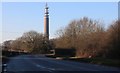
9
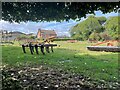
Reservoir & Rain Gauges
A Thames Water reservoir site with two rain gauges on the lawn.
Image: © Des Blenkinsopp
Taken: 19 Sep 2013
0.11 miles
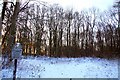
10
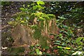
Moss covered tree stump in Aston Wood
Image: © Steve Daniels
Taken: 28 Aug 2009
0.12 miles