IMAGES TAKEN NEAR TO
Marlow Road, HIGH WYCOMBE, HP14 3QJ
Introduction
This page details the photographs taken nearby to Marlow Road, HP14 3QJ by members of the Geograph project.
The Geograph project started in 2005 with the aim of publishing, organising and preserving representative images for every square kilometre of Great Britain, Ireland and the Isle of Man.

There are currently over 7.5m images from over14,400 individuals and you can help contribute to the project by visiting https://www.geograph.org.uk
Image Map
Images are licensed for reuse under creativecommons.org/licenses/by-sa/2.0
Notes
- Clicking on the map will re-center to the selected point.
- The higher the marker number, the further away the image location is from the centre of the postcode.
Image Listing (18 Images Found)
Images are licensed for reuse under creativecommons.org/licenses/by-sa/2.0
Image
Details
Distance
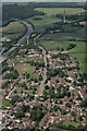
3
Raven Road, Stokenchurch
This is a square of two halves. Bisected by the M40, this part is all suburban housing while to the south west is all fields and woods.
Image: © Des Blenkinsopp
Taken: 9 Apr 2015
0.05 miles
4
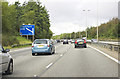
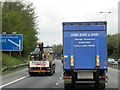
M40 at Stokenchurch
Northbound, between junctions 4 and 5
Image: © MrC
Taken: 13 Oct 2012
0.10 miles
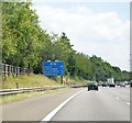
7
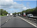
M40 motorway in cutting near Stokenchurch
Image: © Peter Whatley
Taken: 12 Apr 2011
0.10 miles