IMAGES TAKEN NEAR TO
Spring Coppice, HIGH WYCOMBE, HP14 3NU
Introduction
This page details the photographs taken nearby to Spring Coppice, HP14 3NU by members of the Geograph project.
The Geograph project started in 2005 with the aim of publishing, organising and preserving representative images for every square kilometre of Great Britain, Ireland and the Isle of Man.

There are currently over 7.5m images from over14,400 individuals and you can help contribute to the project by visiting https://www.geograph.org.uk
Image Map
Images are licensed for reuse under creativecommons.org/licenses/by-sa/2.0
Notes
- Clicking on the map will re-center to the selected point.
- The higher the marker number, the further away the image location is from the centre of the postcode.
Image Listing (6 Images Found)
Images are licensed for reuse under creativecommons.org/licenses/by-sa/2.0
Image
Details
Distance
1
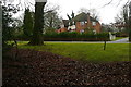
Houses off Lane End Road
There is a group of about five large detached houses here, tucked away off Lane End Road, which offers very good access to the M40. They are all different but clearly built at the same time by the same architect. We reckoned this one had about seven bedrooms.
Image: © Graham Horn
Taken: 29 Jan 2012
0.03 miles
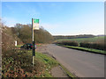
2
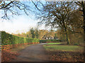
Spring Coppice
Taking its name from the wood at the end, Spring Coppice is a private road of around half a dozen large, prosperous houses behind big hedges.
Image: © Des Blenkinsopp
Taken: 17 Jan 2017
0.04 miles
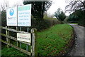
3
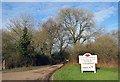
Entrance to Grove Farm
Home of the Grove Riding School.
Image: © Des Blenkinsopp
Taken: 17 Jan 2017
0.09 miles
4
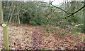
Footpath to Lane End Road
This is a useful little footpath through light woodland to avoid some road walking to the south of Spring Coppice. It also usefully cuts the corner of this square, maximising points collection potential.
Image: © Graham Horn
Taken: 29 Jan 2012
0.10 miles
6
Fryers Farm Lane
Fryers Farm itself now houses Phoenix Retail Services. There is also a paintball place in one of the woods up here. Fortunately the private road is also a public footpath with plenty of route options further north-west.
Image: © Graham Horn
Taken: 29 Jan 2012
0.24 miles