IMAGES TAKEN NEAR TO
Handleton Common, HIGH WYCOMBE, HP14 3LA
Introduction
This page details the photographs taken nearby to Handleton Common, HP14 3LA by members of the Geograph project.
The Geograph project started in 2005 with the aim of publishing, organising and preserving representative images for every square kilometre of Great Britain, Ireland and the Isle of Man.

There are currently over 7.5m images from over14,400 individuals and you can help contribute to the project by visiting https://www.geograph.org.uk
Image Map (Loading...)


Getting Data...Please wait
Leaflet Map data © OpenStreetMap
Images are licensed for reuse under creativecommons.org/licenses/by-sa/2.0
Notes
- Clicking on the map will re-center to the selected point.
- The higher the marker number, the further away the image location is from the centre of the postcode.
Image Listing (21 Images Found)
Images are licensed for reuse under creativecommons.org/licenses/by-sa/2.0
Image
Details
Distance
1
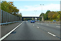
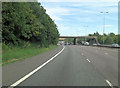
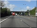
M40 towards Oxford
Bullocks Farm Lane crosses the bridge.
Image: © Robin Webster
Taken: 20 Oct 2018
0.08 miles
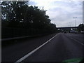
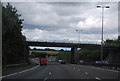
4
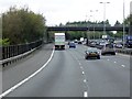
Northbound M40, Bullocks Farm Lane Bridge
Image: © David Dixon
Taken: 17 May 2013
0.08 miles
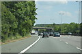
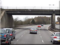
5
M40 Motorway - Bullocks Farm Lane bridge
Image: © Peter Whatley
Taken: 12 Apr 2011
0.08 miles
6
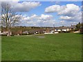
Handleton Common, Lane End
The northern end of the common which stretches into the village centre is bound on its eastern side with bungalows. An older flint house is to the left.
Image: © Andrew Smith
Taken: 12 Apr 2008
0.09 miles