IMAGES TAKEN NEAR TO
Slayter Road, HIGH WYCOMBE, HP14 3JQ
Introduction
This page details the photographs taken nearby to Slayter Road, HP14 3JQ by members of the Geograph project.
The Geograph project started in 2005 with the aim of publishing, organising and preserving representative images for every square kilometre of Great Britain, Ireland and the Isle of Man.

There are currently over 7.5m images from over14,400 individuals and you can help contribute to the project by visiting https://www.geograph.org.uk
Image Map
Images are licensed for reuse under creativecommons.org/licenses/by-sa/2.0
Notes
- Clicking on the map will re-center to the selected point.
- The higher the marker number, the further away the image location is from the centre of the postcode.
Image Listing (10 Images Found)
Images are licensed for reuse under creativecommons.org/licenses/by-sa/2.0
Image
Details
Distance
1
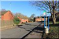
Simmons Way, Lane End
The original village of Lane End was an old settlement along the B482, but the late 20th century brought a big expansion with suburban style development of land between the old village and the M40.
Image: © Des Blenkinsopp
Taken: 18 Jan 2017
0.07 miles
2
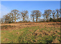
Millennium Park, Lane End
That's the name the map puts on this bit of land. It's covered with paths and looks quite well used by dog walkers etc. but it's more of a field than a park.
Image: © Des Blenkinsopp
Taken: 18 Jan 2017
0.11 miles
3
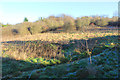
Vacant Land off Beech Avenue
Some bits of old farmland remain from before the rest of the area was built over.
No longer of much agricultural use, it's a bit of open space for local people.
Image: © Des Blenkinsopp
Taken: 18 Jan 2017
0.17 miles
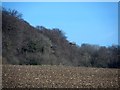
4
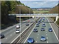
The M40, Lane End
Viewed from the road to Wycombe. Wheeler End can be seen in mid distance with the transmitter at Stokenchurch in the far distance.
Image: © Andrew Smith
Taken: 12 Apr 2008
0.20 miles
6
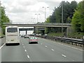
Southbound M40, near Lane End
The first bridge is a footbridge; the second carries Park Lane over the motorway.
Image: © David Dixon
Taken: 13 May 2013
0.24 miles
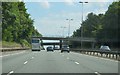
9
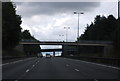
Two bridges across the M40
The near bridge is a footbridge the far one is Park Lane Bridge.
Image: © N Chadwick
Taken: 17 Jul 2011
0.24 miles
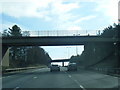
10
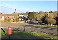
Beech Avenue and Park Lane, Lane End
Image: © Des Blenkinsopp
Taken: 18 Jan 2017
0.24 miles