IMAGES TAKEN NEAR TO
Moor Common, HIGH WYCOMBE, HP14 3HT
Introduction
This page details the photographs taken nearby to Moor Common, HP14 3HT by members of the Geograph project.
The Geograph project started in 2005 with the aim of publishing, organising and preserving representative images for every square kilometre of Great Britain, Ireland and the Isle of Man.

There are currently over 7.5m images from over14,400 individuals and you can help contribute to the project by visiting https://www.geograph.org.uk
Image Map
Images are licensed for reuse under creativecommons.org/licenses/by-sa/2.0
Notes
- Clicking on the map will re-center to the selected point.
- The higher the marker number, the further away the image location is from the centre of the postcode.
Image Listing (7 Images Found)
Images are licensed for reuse under creativecommons.org/licenses/by-sa/2.0
Image
Details
Distance
1
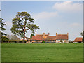
Moor Farm
I suppose I could have gone closer to get more of the building, but I quite like this shot from a distance.
Image: © Des Blenkinsopp
Taken: 9 Apr 2015
0.03 miles

3
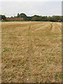
Footpath through stubble
Moor Farm beyond.
Image: © David Hawgood
Taken: 30 Aug 2008
0.10 miles
4
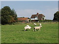
Sheep at Moor Common
View from public footpath across this field.
Image: © David Hawgood
Taken: 30 Aug 2008
0.12 miles
5
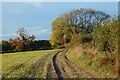
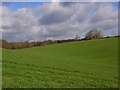
Track and farmland, Great Marlow
A footpath is actually on the other side of the hedge but the track on this side was less muddy, so preferred. The copse is on the site of a chapel.
Image: © Andrew Smith
Taken: 25 Oct 2020
0.22 miles
6
Farmland, Lane End
Looking up from the edge of Bottom Wood. The trees to the right are the ones shown in Image
Image: © Andrew Smith
Taken: 12 Apr 2008
0.24 miles
7
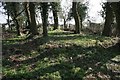
Moor Common
Marked on the map as the remains of an old chapel, all that remains, sadly, is a pile of flints covered by vegetation.
Image: © Brendan and Ruth McCartney
Taken: 2 Apr 2005
0.25 miles