IMAGES TAKEN NEAR TO
Finings Road, HIGH WYCOMBE, HP14 3EU
Introduction
This page details the photographs taken nearby to Finings Road, HP14 3EU by members of the Geograph project.
The Geograph project started in 2005 with the aim of publishing, organising and preserving representative images for every square kilometre of Great Britain, Ireland and the Isle of Man.

There are currently over 7.5m images from over14,400 individuals and you can help contribute to the project by visiting https://www.geograph.org.uk
Image Map
Images are licensed for reuse under creativecommons.org/licenses/by-sa/2.0
Notes
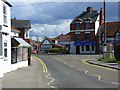
- Clicking on the map will re-center to the selected point.
- The higher the marker number, the further away the image location is from the centre of the postcode.
Image Listing (46 Images Found)
Images are licensed for reuse under creativecommons.org/licenses/by-sa/2.0
Image
Details
Distance
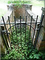
2
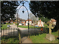
Through the Churchyard Gate
Part of Lane End village.
Image: © Des Blenkinsopp
Taken: 9 Apr 2015
0.08 miles
3
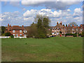
Handleton Common, Lane End
This is the view across commonland immediately north of the village centre car park. The terrace of cottages is on The Row and is listed.
Image: © Andrew Smith
Taken: 12 Apr 2008
0.09 miles
4
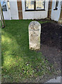
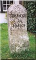
Old Milestone by the B482 in Lane End, High Wycombe
Carved stone post by the B482, in parish of Lane End (Wycombe District), High Street; by Lane End Village Hall, on lawn in front of hall entrance, on West side of road. Marlow pillar, erected by the Gt Marlow & Stokenchurch turnpike trust in the 19th century.
Inscription reads:-
STOKENCHURCH
4½
MARLOW
(5)
Buckinghamshire HER.
HER Number: 1354300000 https://www.heritagegateway.org.uk/Gateway/Results_Single.aspx?uid=MBC25646&resourceID=1024
Milestone Society National ID: BU_MWST05
Image: © Tim Hanby
Taken: 27 Feb 2024
0.10 miles
5
Old Milestone by the B482 in Lane End, High Wycombe
Carved stone post by the B482, in parish of Lane End (Wycombe District), High Street; by Lane End Village Hall, on lawn in front of hall entrance, on West side of road. Marlow pillar, erected by the Gt Marlow & Stokenchurch turnpike trust in the 19th century.
Inscription reads:-
STOKENCHURCH
4½
MARLOW
(5)
Buckinghamshire HER.
HER Number: 1354300000 https://www.heritagegateway.org.uk/Gateway/Results_Single.aspx?uid=MBC25646&resourceID=1024
Milestone Society National ID: BU_MWST05
Image: © A Rosevear & J Higgins
Taken: 1 Aug 2002
0.10 miles
6
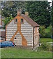
Cottages at Lane End
Seen from the churchyard. The materials - flint and red brick - are very typical of the Chilterns, and the striking use made of them here is typical of this village.
Image: © Stefan Czapski
Taken: 8 Oct 2013
0.12 miles
8
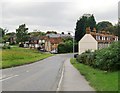
Approaching Lane End from the south
View north along Church Road. A portion of the churchyard wall is visible on the left.
Image: © Stefan Czapski
Taken: 8 Oct 2013
0.13 miles
9
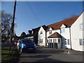
High Street, Lane End
The B482 at the junction with Church Road. On the left is the post office. This is the western end of a relatively large retail area for a village of this size.
Image: © Andrew Smith
Taken: 12 Apr 2008
0.13 miles
10
Black Well at Lane End
This former well is in The Row HP14 3JS, and dates from about 1850. It was restored through local effort in 1986, but is now kept securely locked.
Image: © David Hillas
Taken: 24 Jun 2023
0.13 miles