IMAGES TAKEN NEAR TO
Stokenchurch, HIGH WYCOMBE, HP14 3EF
Introduction
This page details the photographs taken nearby to HP14 3EF by members of the Geograph project.
The Geograph project started in 2005 with the aim of publishing, organising and preserving representative images for every square kilometre of Great Britain, Ireland and the Isle of Man.

There are currently over 7.5m images from over14,400 individuals and you can help contribute to the project by visiting https://www.geograph.org.uk
Image Map
Images are licensed for reuse under creativecommons.org/licenses/by-sa/2.0
Notes
- Clicking on the map will re-center to the selected point.
- The higher the marker number, the further away the image location is from the centre of the postcode.
Image Listing (5 Images Found)
Images are licensed for reuse under creativecommons.org/licenses/by-sa/2.0
Image
Details
Distance
1
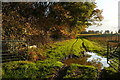
Track at Ibstone Road
This track runs parallel to Ibstone Road. It is not a public right of way and seems just to provide access to fields.
Image: © Graham Horn
Taken: 7 Nov 2010
0.07 miles
2
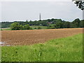
Ploughed field opposite Lower Studdridge Farm
There are discrepancies between different scale OS maps in this area - view is from just beside the road where there is a narrow belt of woodland. The microwave tower at Stokenchurch is visible in the photo.
Image: © David Hawgood
Taken: 5 Jun 2008
0.10 miles
3
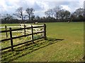
Pasture, Stokenchurch
Beside the entrance to Studdridge Farm. The trees are beside Ibstone Road.
Image: © Andrew Smith
Taken: 27 Mar 2008
0.15 miles
4
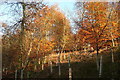
Autumn colour at Wellground
The late afternoon sun, when it did come out, made an impression on the remaining leaves in the trees near Wellground Farm.
Image: © Graham Horn
Taken: 7 Nov 2010
0.24 miles
5
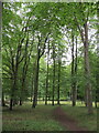
Beech trees in Commonhill Wood
On a public footpath near Studdridge Farm.
Image: © David Hawgood
Taken: 23 Aug 2021
0.25 miles