IMAGES TAKEN NEAR TO
Ridge Close, HIGH WYCOMBE, HP14 3BX
Introduction
This page details the photographs taken nearby to Ridge Close, HP14 3BX by members of the Geograph project.
The Geograph project started in 2005 with the aim of publishing, organising and preserving representative images for every square kilometre of Great Britain, Ireland and the Isle of Man.

There are currently over 7.5m images from over14,400 individuals and you can help contribute to the project by visiting https://www.geograph.org.uk
Image Map
Images are licensed for reuse under creativecommons.org/licenses/by-sa/2.0
Notes
- Clicking on the map will re-center to the selected point.
- The higher the marker number, the further away the image location is from the centre of the postcode.
Image Listing (42 Images Found)
Images are licensed for reuse under creativecommons.org/licenses/by-sa/2.0
Image
Details
Distance
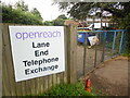
2
Telephone Exchange, Lane End, Bucks
Situated in Marlow Road, this TE dates from 1969 and has the code SMLN. The former TE is now a private dwelling just along that same road. This TE now provides telephone and broadband services to 1,949 residential and 120 non-residential premises in Lane End plus Bolter End, Cadmore End, Frieth, Piddington and Wheeler End nearby. The numbering range of this TE is (01494) 88xxxx, the (01494) referring to the High Wycombe group of sixteen TEs, and the postcode for both is HP14 3JP.
Image: © David Hillas
Taken: 28 Apr 2009
0.09 miles
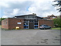
3
Former factory, former bus garage, boarded up
This large site in Lane End was most recently the premises of Elga Labwater, part of Veolia. Before that it was a bus garage of Chiltern Bus Company, see http://www.oxford-chiltern-bus-page.co.uk/230106.htm .
Image: © David Hawgood
Taken: 30 Aug 2008
0.09 miles
4
Entrance to Lane End Telephone Exchange
Taken in Marlow Road (B482), this photo shows the entrance to Lane End TE with the blue metal gates and the board erected by Openreach, the company that maintains the telephone and broadband network in the United Kingdom. The TE can be seen in the distance to the right of the photo https://www.geograph.org.uk/photo/1277068 refers.
Image: © David Hillas
Taken: 28 Aug 2023
0.09 miles
5
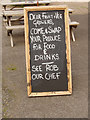
"Swap your produce for food and drinks"
Blackboard sign outside the Grouse and Ale in Lane End Image offers fruit and vegetable growers the opportunity to barter their produce in the pub.
Image: © David Hawgood
Taken: 30 Aug 2008
0.10 miles
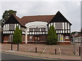
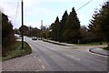
6
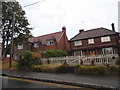
Houses on Marlow Road, Lane End
The house on the left recently replaced a mock tudor one of around the same size.
Image: © David Howard
Taken: 12 Jul 2015
0.10 miles
7
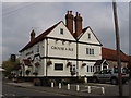
Grouse and Ale pub, Lane End
Formerly the Clayton Arms, this pub is on the B482 through the village.
Image: © David Hawgood
Taken: 30 Aug 2008
0.10 miles
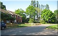
8
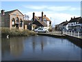
Lane End Pond
Lane End Pond by Marlow Road
Image: © Shaun Ferguson
Taken: 22 Mar 2008
0.11 miles
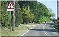
10
Marlow Road in Lane End
The road is covered in hailstones.
Image: © Steve Daniels
Taken: 27 Jan 2013
0.12 miles