IMAGES TAKEN NEAR TO
Oakwood Place, HIGH WYCOMBE, HP14 3BQ
Introduction
This page details the photographs taken nearby to Oakwood Place, HP14 3BQ by members of the Geograph project.
The Geograph project started in 2005 with the aim of publishing, organising and preserving representative images for every square kilometre of Great Britain, Ireland and the Isle of Man.

There are currently over 7.5m images from over14,400 individuals and you can help contribute to the project by visiting https://www.geograph.org.uk
Image Map
Images are licensed for reuse under creativecommons.org/licenses/by-sa/2.0
Notes
- Clicking on the map will re-center to the selected point.
- The higher the marker number, the further away the image location is from the centre of the postcode.
Image Listing (43 Images Found)
Images are licensed for reuse under creativecommons.org/licenses/by-sa/2.0
Image
Details
Distance
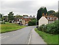
1
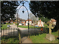
Through the Churchyard Gate
Part of Lane End village.
Image: © Des Blenkinsopp
Taken: 9 Apr 2015
0.03 miles
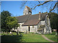
3
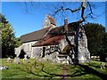
Holy Trinity, Lane End
Built in 1877 to the design of John Oldrid Scott (1841-1913) son of Sir George Gilbert Scott
Image: © Bikeboy
Taken: 18 Feb 2015
0.07 miles
4
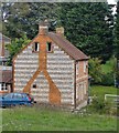
Cottages at Lane End
Seen from the churchyard. The materials - flint and red brick - are very typical of the Chilterns, and the striking use made of them here is typical of this village.
Image: © Stefan Czapski
Taken: 8 Oct 2013
0.07 miles
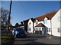
5
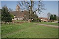
Approaching Lane End from the south
View north along Church Road. A portion of the churchyard wall is visible on the left.
Image: © Stefan Czapski
Taken: 8 Oct 2013
0.08 miles
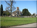
6
Lane End: Holy Trinity Church
The church is a Grade II Listed Building although it was only built in 1877 replacing a short-lived earlier church. By a coincidence the earliest edition of the large scale Ordnance Survey map currently available online does date from 1877 and shows the footprint of the earlier church, whose long axis was orientated north-south rather than the east-west configuration of the present-day building.
The English Heritage Listed Buildings website describes it thus:-
"Parish church. Dated 1877 on stone dedication tablet at E. end. By J. Oldrid Scott. Flint with stone dressings, tiled roofs. Nave, N. porch, tower in angle with small N. transept, N. chapel, chancel and S, vestry. In Early English style with lancet windows. Off-set buttresses, stone sill course, flint and stone chequer patterning to tops of gables. Nave has 2 lancets and cusped roundel to W., 5 lancets to S. with arched door to left, and 2 lancets to N. Gabled N. porch at right end, with double chamfered arch, and paired cusped lights to each side. Tower, raised 1901, is of 3 stages with saddle-back roof, clocks in gables, paired cusped openings to bell-chamber, lancets, and W. door. Triple lancets in small gable of N. transept, the central light taller. N. chapel has 3 lancets to N. and traceried roundel to E. Chancel has 3-light traceried E. window with carved head hoodmould stops. Door and 2-light window to vestry. Interior: nave has 6-bay roof of re-used medieval timbers from barn at Bisham Abbey, with chamfered arch-braces to collars, and chamfered arched wind-braces."
Image: © Nigel Cox
Taken: 19 Mar 2011
0.08 miles
7
Lane End: Holy Trinity Church
This is the view from Church Road, showing the saddleback roof of the tower. For a description please see Image
Image: © Nigel Cox
Taken: 19 Mar 2011
0.08 miles
8
Lane End
Church Road approaching the village centre as it passes the church. The village has many attractive brick and flint cottages.
Image: © Andrew Smith
Taken: 12 Apr 2008
0.10 miles
9
Lane End
Looking north with the Parish Church of All Saints on the left.
Image: © Brendan and Ruth McCartney
Taken: 2 Apr 2005
0.10 miles
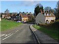
10
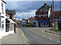
High Street, Lane End
The B482 at the junction with Church Road. On the left is the post office. This is the western end of a relatively large retail area for a village of this size.
Image: © Andrew Smith
Taken: 12 Apr 2008
0.10 miles