IMAGES TAKEN NEAR TO
Bullocks Farm Lane, HIGH WYCOMBE, HP14 3AZ
Introduction
This page details the photographs taken nearby to Bullocks Farm Lane, HP14 3AZ by members of the Geograph project.
The Geograph project started in 2005 with the aim of publishing, organising and preserving representative images for every square kilometre of Great Britain, Ireland and the Isle of Man.

There are currently over 7.5m images from over14,400 individuals and you can help contribute to the project by visiting https://www.geograph.org.uk
Image Map
Images are licensed for reuse under creativecommons.org/licenses/by-sa/2.0
Notes
- Clicking on the map will re-center to the selected point.
- The higher the marker number, the further away the image location is from the centre of the postcode.
Image Listing (3 Images Found)
Images are licensed for reuse under creativecommons.org/licenses/by-sa/2.0
Image
Details
Distance
1
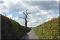
Bullocks Farm Lane
Narrow and thick hedged, with some very dodgy passing places. Seems to see a lot more traffic than it should.
Image: © Des Blenkinsopp
Taken: 2 May 2017
0.13 miles
2
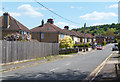
King Street, Piddington
Piddington is a 20th century development. A furniture factory was built alongside the main road and a few streets of suburban housing were built up the hill behind it. http://en.wikipedia.org/wiki/Piddington,_Buckinghamshire
Image: © Des Blenkinsopp
Taken: 3 Jun 2013
0.21 miles
3
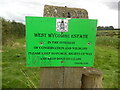
West Wycombe Estate Notice
Located on the footpath between Denham Farm and Great Wood, this notice has been erected by the West Wycombe Estate and has the following wording:
WEST WYCOMBE ESTATE
IN THE INTEREST
OF CONSERVATION AND WILDLIFE
PLEASE KEEP TO PUBLIC RIGHTS OF WAY
AND KEEP DOGS ON LEADS
THANK YOU.
Image: © David Hillas
Taken: 28 Aug 2023
0.24 miles