IMAGES TAKEN NEAR TO
Riverbank, HEMEL HEMPSTEAD, HP1 3SG
Introduction
This page details the photographs taken nearby to Riverbank, HP1 3SG by members of the Geograph project.
The Geograph project started in 2005 with the aim of publishing, organising and preserving representative images for every square kilometre of Great Britain, Ireland and the Isle of Man.

There are currently over 7.5m images from over14,400 individuals and you can help contribute to the project by visiting https://www.geograph.org.uk
Image Map
Images are licensed for reuse under creativecommons.org/licenses/by-sa/2.0
Notes
- Clicking on the map will re-center to the selected point.
- The higher the marker number, the further away the image location is from the centre of the postcode.
Image Listing (17 Images Found)
Images are licensed for reuse under creativecommons.org/licenses/by-sa/2.0
Image
Details
Distance
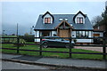
4
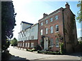
Converted Water Mill
Water mill converted into flats.
Image: © Tom Presland
Taken: 31 Aug 2010
0.03 miles
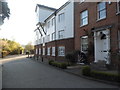
9
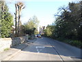
Leighton Buzzard Road, Piccotts End
The short path is to Piccotts End Road which you can see through it.
Image: © David Howard
Taken: 23 Nov 2019
0.07 miles