IMAGES TAKEN NEAR TO
Leighton Buzzard Road, HEMEL HEMPSTEAD, HP1 3BD
Introduction
This page details the photographs taken nearby to Leighton Buzzard Road, HP1 3BD by members of the Geograph project.
The Geograph project started in 2005 with the aim of publishing, organising and preserving representative images for every square kilometre of Great Britain, Ireland and the Isle of Man.

There are currently over 7.5m images from over14,400 individuals and you can help contribute to the project by visiting https://www.geograph.org.uk
Image Map
Images are licensed for reuse under creativecommons.org/licenses/by-sa/2.0
Notes
- Clicking on the map will re-center to the selected point.
- The higher the marker number, the further away the image location is from the centre of the postcode.
Image Listing (4 Images Found)
Images are licensed for reuse under creativecommons.org/licenses/by-sa/2.0
Image
Details
Distance
1
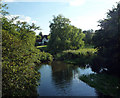
View South from Bridge at Water End
The river flows through reed beds and past a large house. The river's flow is much greater here than after it has passed through the ponds and water treatment works half a mile downstream.
Image: © Tom Presland
Taken: 31 Aug 2010
0.13 miles
2
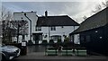
The Red Lion Pub, Leighton Buzzard Road
Image: © Bryn Holmes
Taken: 24 Dec 2022
0.19 miles
3
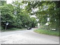
Red Lion Lane at the junction of Dagnall Road
Image: © David Howard
Taken: 13 Jul 2017
0.21 miles
4
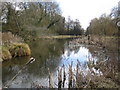
River Gade at Water End
Viewed looking southwards and downstream, this view is in the opposite direction to Image
Image: © Nigel Cox
Taken: 19 Mar 2006
0.22 miles