IMAGES TAKEN NEAR TO
Everest Road, HIGH WYCOMBE, HP13 7RG
Introduction
This page details the photographs taken nearby to Everest Road, HP13 7RG by members of the Geograph project.
The Geograph project started in 2005 with the aim of publishing, organising and preserving representative images for every square kilometre of Great Britain, Ireland and the Isle of Man.

There are currently over 7.5m images from over14,400 individuals and you can help contribute to the project by visiting https://www.geograph.org.uk
Image Map
Images are licensed for reuse under creativecommons.org/licenses/by-sa/2.0
Notes
- Clicking on the map will re-center to the selected point.
- The higher the marker number, the further away the image location is from the centre of the postcode.
Image Listing (5 Images Found)
Images are licensed for reuse under creativecommons.org/licenses/by-sa/2.0
Image
Details
Distance
1
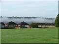
Morning mist hangs in the Wycombe valley
Photo taken from the Highcrest Community School playing fields
Image: © Peter Jemmett
Taken: 9 Oct 2005
0.09 miles
2
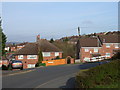
Everest-themed estate, High Wycombe
Hillary Road at the junction with Tenzing Drive.
Image: © Andrew Smith
Taken: 4 Apr 2006
0.12 miles
3
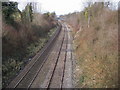
Railway line heading towards High Wycombe
From Hatters Lane bridge railway line heading towards High Wycombe
Image: © Shaun Ferguson
Taken: 25 Feb 2008
0.17 miles
5
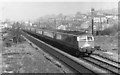
The Birmingham Pullman passing High Wycombe
These rather smart diesel express trains ran on this line from 1960 to 1967. The train is travelling towards London (Paddington). Visible on the left of the picture are the piles of sawn timber being seasoned outside for use by the local furniture factories.
Image: © john bristow
Taken: 25 Apr 1962
0.23 miles