IMAGES TAKEN NEAR TO
Rushbrooke Close, HIGH WYCOMBE, HP13 7QN
Introduction
This page details the photographs taken nearby to Rushbrooke Close, HP13 7QN by members of the Geograph project.
The Geograph project started in 2005 with the aim of publishing, organising and preserving representative images for every square kilometre of Great Britain, Ireland and the Isle of Man.

There are currently over 7.5m images from over14,400 individuals and you can help contribute to the project by visiting https://www.geograph.org.uk
Image Map (Loading...)


Getting Data...Please wait
Leaflet Map data © OpenStreetMap
Images are licensed for reuse under creativecommons.org/licenses/by-sa/2.0
Notes
- Clicking on the map will re-center to the selected point.
- The higher the marker number, the further away the image location is from the centre of the postcode.
Image Listing (13 Images Found)
Images are licensed for reuse under creativecommons.org/licenses/by-sa/2.0
Image
Details
Distance
1
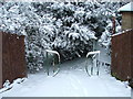
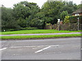
Gateway to Kingswood
Entrance into Kingswood from Rushbrooke Close after a snowfall, Feb 2007
Image: © Peter Jemmett
Taken: 8 Feb 2007
0.06 miles
2
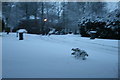
Magnolia Dene, Hazlemere
Snow in 2009
Image: © Veronica Bartyla
Taken: 5 Feb 2009
0.11 miles
3
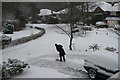
Magnolia Dene, Hazlemere
2010 Snowtime!
Image: © Veronica Bartyla
Taken: 12 Jan 2009
0.11 miles
5
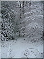
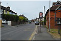
Footpath off Totteridge Lane
Footpath off Totteridge Lane into King's Wood
Image: © Shaun Ferguson
Taken: 7 Sep 2008
0.16 miles
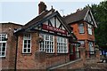
7
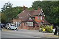
The Dolphin, Totteridge
Suburban pub on the edge of a small wood. Pictured on a less dramatic day than Image
Image: © Des Blenkinsopp
Taken: 25 Jan 2018
0.23 miles
10
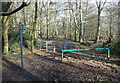
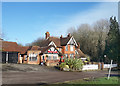
Entrance to King's Wood
A small patch of Chiltern beech woodland surviving in the midst of encroaching housing.
Image: © Des Blenkinsopp
Taken: 25 Jan 2018
0.24 miles