IMAGES TAKEN NEAR TO
Linchfield, HIGH WYCOMBE, HP13 7QH
Introduction
This page details the photographs taken nearby to Linchfield, HP13 7QH by members of the Geograph project.
The Geograph project started in 2005 with the aim of publishing, organising and preserving representative images for every square kilometre of Great Britain, Ireland and the Isle of Man.

There are currently over 7.5m images from over14,400 individuals and you can help contribute to the project by visiting https://www.geograph.org.uk
Image Map
Images are licensed for reuse under creativecommons.org/licenses/by-sa/2.0
Notes
- Clicking on the map will re-center to the selected point.
- The higher the marker number, the further away the image location is from the centre of the postcode.
Image Listing (17 Images Found)
Images are licensed for reuse under creativecommons.org/licenses/by-sa/2.0
Image
Details
Distance
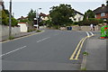

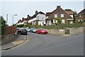
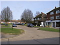
8
Cambridge Crescent
Estate in the Totteridge area of Wycombe.
Image: © Andrew Smith
Taken: 4 Apr 2006
0.13 miles
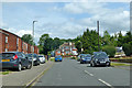
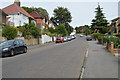
9
The Quadrangle
Small parade of shops on the Quadrangle
Image: © Shaun Ferguson
Taken: 25 Feb 2008
0.13 miles