IMAGES TAKEN NEAR TO
Nelson Close, HIGH WYCOMBE, HP13 7NS
Introduction
This page details the photographs taken nearby to Nelson Close, HP13 7NS by members of the Geograph project.
The Geograph project started in 2005 with the aim of publishing, organising and preserving representative images for every square kilometre of Great Britain, Ireland and the Isle of Man.

There are currently over 7.5m images from over14,400 individuals and you can help contribute to the project by visiting https://www.geograph.org.uk
Image Map
Images are licensed for reuse under creativecommons.org/licenses/by-sa/2.0
Notes
- Clicking on the map will re-center to the selected point.
- The higher the marker number, the further away the image location is from the centre of the postcode.
Image Listing (34 Images Found)
Images are licensed for reuse under creativecommons.org/licenses/by-sa/2.0
Image
Details
Distance
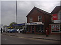
3
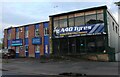
A40 Tyres on London Road, High Wycombe
Image: © David Howard
Taken: 27 Sep 2022
0.06 miles
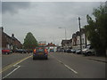
7
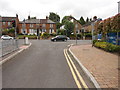
Sierra Road, High Wycombe
Pelican Crossing at the junction with the A40 London Road.
Image: © Dave Hitchborne
Taken: 14 Jun 2013
0.13 miles
8
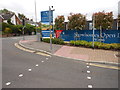
Sierra Road, High Wycombe
Pelican Crossing.
Image: © Dave Hitchborne
Taken: 14 Jun 2013
0.13 miles
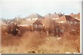
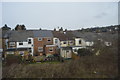
9
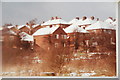
View of cul-de-sac of Kendalls Close
View from HP13 7NU looking towards HP13 7NN
Image: © Tony White
Taken: 13 Jan 1985
0.14 miles
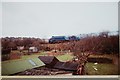
10
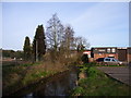
River Wye
At Wycombe Marsh, in an area of retail and industrial units.
Image: © Andrew Smith
Taken: 4 Apr 2006
0.14 miles