IMAGES TAKEN NEAR TO
Firs Close, HIGH WYCOMBE, HP13 7LX
Introduction
This page details the photographs taken nearby to Firs Close, HP13 7LX by members of the Geograph project.
The Geograph project started in 2005 with the aim of publishing, organising and preserving representative images for every square kilometre of Great Britain, Ireland and the Isle of Man.

There are currently over 7.5m images from over14,400 individuals and you can help contribute to the project by visiting https://www.geograph.org.uk
Image Map
Images are licensed for reuse under creativecommons.org/licenses/by-sa/2.0
Notes
- Clicking on the map will re-center to the selected point.
- The higher the marker number, the further away the image location is from the centre of the postcode.
Image Listing (26 Images Found)
Images are licensed for reuse under creativecommons.org/licenses/by-sa/2.0
Image
Details
Distance
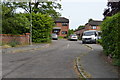
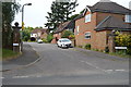
1
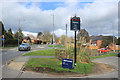
Hatters Lane, High Wycombe
Outside Tesco's at the junction with Hicks Farm Rise.
Image: © Des Blenkinsopp
Taken: 4 Mar 2019
0.04 miles
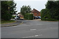
2
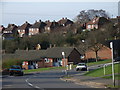
Hollis Road, High Wycombe
Looking down to Hick' Farm Rise, with Hatter's Lane behind.
Image: © Andrew Smith
Taken: 4 Apr 2006
0.04 miles
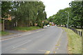
10
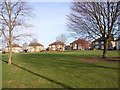
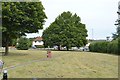
Cambridge Crescent
Estate in the Totteridge area of Wycombe.
Image: © Andrew Smith
Taken: 4 Apr 2006
0.11 miles