IMAGES TAKEN NEAR TO
Hill Street, HIGH WYCOMBE, HP13 7DU
Introduction
This page details the photographs taken nearby to Hill Street, HP13 7DU by members of the Geograph project.
The Geograph project started in 2005 with the aim of publishing, organising and preserving representative images for every square kilometre of Great Britain, Ireland and the Isle of Man.

There are currently over 7.5m images from over14,400 individuals and you can help contribute to the project by visiting https://www.geograph.org.uk
Image Map
Images are licensed for reuse under creativecommons.org/licenses/by-sa/2.0
Notes
- Clicking on the map will re-center to the selected point.
- The higher the marker number, the further away the image location is from the centre of the postcode.
Image Listing (30 Images Found)
Images are licensed for reuse under creativecommons.org/licenses/by-sa/2.0
Image
Details
Distance
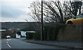
4
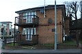
Flats on Cock Lane, Wycombe Marsh
Compare and contrast. https://www.geograph.org.uk/photo/5663695
Image: © David Howard
Taken: 17 Feb 2022
0.11 miles
7
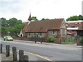
Wycombe Marsh: St Anne's Church
The building of the church commenced in 1858 to the designs of the architect George Edwin Street in the Early English style. Constructed of flint rubble, brick and ashlar, and with the bell cote at its western end, it is a Grade II Listed Building. The street in front is the A40 London Road.
Image: © Nigel Cox
Taken: 5 Jun 2012
0.12 miles