IMAGES TAKEN NEAR TO
Peatey Court, Princes Gate, HIGH WYCOMBE, HP13 7AY
Introduction
This page details the photographs taken nearby to Peatey Court, Princes Gate, HP13 7AY by members of the Geograph project.
The Geograph project started in 2005 with the aim of publishing, organising and preserving representative images for every square kilometre of Great Britain, Ireland and the Isle of Man.

There are currently over 7.5m images from over14,400 individuals and you can help contribute to the project by visiting https://www.geograph.org.uk
Image Map
Images are licensed for reuse under creativecommons.org/licenses/by-sa/2.0
Notes
- Clicking on the map will re-center to the selected point.
- The higher the marker number, the further away the image location is from the centre of the postcode.
Image Listing (35 Images Found)
Images are licensed for reuse under creativecommons.org/licenses/by-sa/2.0
Image
Details
Distance
1
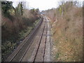
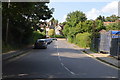
Railway line heading towards High Wycombe
From Hatters Lane bridge railway line heading towards High Wycombe
Image: © Shaun Ferguson
Taken: 25 Feb 2008
0.11 miles
2
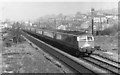
The Birmingham Pullman passing High Wycombe
These rather smart diesel express trains ran on this line from 1960 to 1967. The train is travelling towards London (Paddington). Visible on the left of the picture are the piles of sawn timber being seasoned outside for use by the local furniture factories.
Image: © john bristow
Taken: 25 Apr 1962
0.11 miles
3
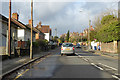
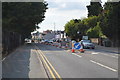
A40 London Road, High Wycombe
Heading west.
Image: © Robin Webster
Taken: 8 Dec 2019
0.12 miles
4
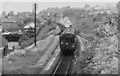
Branch train leaving High Wycombe in 1962
An autocoach bound for Maidenhead and propelled by Class 14XX locomotive No. 1445 drops away from the Main Line, having just passed over Gordon Road. The line from Maidenhead to High Wycombe opened in 1854 as the Wycombe Railway and the Wycombe to Bourne End section closed in 1970. The alignment where the photograph was taken has been obliterated in recent years by the construction of the Princes Gate access road. The building on the left of the picture is the former Gordon Road Infants' School (my first school!).
Image: © john bristow
Taken: 2 Jun 1962
0.14 miles
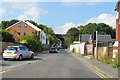
8
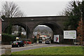
High Wycombe
Railway viaduct, seen beyond the end of Totteridge Avenue, at the junction with Bowerdean Road.
Image: © Peter Trimming
Taken: 23 Mar 2016
0.17 miles
10
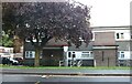
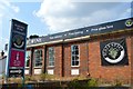
Edgewood on London Road, High Wycombe
Image: © David Howard
Taken: 27 Sep 2022
0.18 miles