IMAGES TAKEN NEAR TO
Rosebery Avenue, HIGH WYCOMBE, HP13 7AL
Introduction
This page details the photographs taken nearby to Rosebery Avenue, HP13 7AL by members of the Geograph project.
The Geograph project started in 2005 with the aim of publishing, organising and preserving representative images for every square kilometre of Great Britain, Ireland and the Isle of Man.

There are currently over 7.5m images from over14,400 individuals and you can help contribute to the project by visiting https://www.geograph.org.uk
Image Map
Images are licensed for reuse under creativecommons.org/licenses/by-sa/2.0
Notes
- Clicking on the map will re-center to the selected point.
- The higher the marker number, the further away the image location is from the centre of the postcode.
Image Listing (19 Images Found)
Images are licensed for reuse under creativecommons.org/licenses/by-sa/2.0
Image
Details
Distance
1
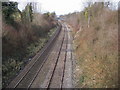
Railway line heading towards High Wycombe
From Hatters Lane bridge railway line heading towards High Wycombe
Image: © Shaun Ferguson
Taken: 25 Feb 2008
0.05 miles
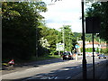
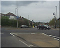
2
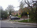
Junction of Pinions Road and London Road
Image: © David Howard
Taken: 13 Apr 2011
0.13 miles
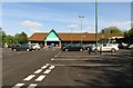
5
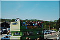
Celebrating a Wycombe Wanderers win in late 80s
Image: © Tony White
Taken: 27 Mar 1988
0.14 miles
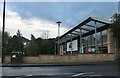
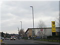
10
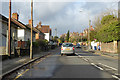
A40 London Road, High Wycombe
Heading west.
Image: © Robin Webster
Taken: 8 Dec 2019
0.19 miles