IMAGES TAKEN NEAR TO
Wesley Dene, HIGH WYCOMBE, HP13 6SJ
Introduction
This page details the photographs taken nearby to Wesley Dene, HP13 6SJ by members of the Geograph project.
The Geograph project started in 2005 with the aim of publishing, organising and preserving representative images for every square kilometre of Great Britain, Ireland and the Isle of Man.

There are currently over 7.5m images from over14,400 individuals and you can help contribute to the project by visiting https://www.geograph.org.uk
Image Map
Images are licensed for reuse under creativecommons.org/licenses/by-sa/2.0
Notes
- Clicking on the map will re-center to the selected point.
- The higher the marker number, the further away the image location is from the centre of the postcode.
Image Listing (498 Images Found)
Images are licensed for reuse under creativecommons.org/licenses/by-sa/2.0
Image
Details
Distance
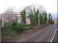
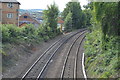
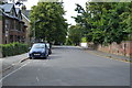
3
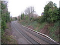
Next stop Saunderton
Heading west out of High Wycombe.
Image: © Mr Ignavy
Taken: 29 Nov 2009
0.02 miles
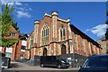
6
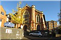
Wesley Methodist Church on Priory Road
Image: © Steve Daniels
Taken: 3 Nov 2013
0.03 miles
10
The Bridesmaid Room
This used to be an excellent second hand bookshop. The new owners have given some thought to their location. They are across the road from All Saints Parish Church.
Image: © Mr Ignavy
Taken: 31 Dec 2008
0.03 miles