IMAGES TAKEN NEAR TO
Amersham Road, HIGH WYCOMBE, HP13 6PN
Introduction
This page details the photographs taken nearby to Amersham Road, HP13 6PN by members of the Geograph project.
The Geograph project started in 2005 with the aim of publishing, organising and preserving representative images for every square kilometre of Great Britain, Ireland and the Isle of Man.

There are currently over 7.5m images from over14,400 individuals and you can help contribute to the project by visiting https://www.geograph.org.uk
Image Map
Images are licensed for reuse under creativecommons.org/licenses/by-sa/2.0
Notes
- Clicking on the map will re-center to the selected point.
- The higher the marker number, the further away the image location is from the centre of the postcode.
Image Listing (49 Images Found)
Images are licensed for reuse under creativecommons.org/licenses/by-sa/2.0
Image
Details
Distance
2
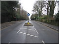
Looking along the lines
View 'up' Amersham Hill, heading out of High Wycombe, taken on New Year's Day, 2009.
Image: © Mr Ignavy
Taken: 1 Jan 2009
0.10 miles
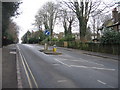
6
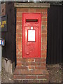
Post Box
At the corner of Shrubbery Road and Amersham Hill.
Image: © Mr Ignavy
Taken: 1 Jan 2009
0.14 miles
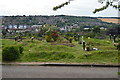
8
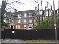
Godstowe Prep School
Shrubbery Road, High Wycombe.
Image: © Mr Ignavy
Taken: 1 Jan 2009
0.15 miles
10
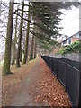
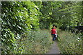
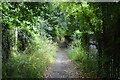
Leaves and fence
Path within Wycombe cemetery.
Image: © Mr Ignavy
Taken: 1 Jan 2009
0.15 miles