IMAGES TAKEN NEAR TO
Shrubbery Close, HIGH WYCOMBE, HP13 6FY
Introduction
This page details the photographs taken nearby to Shrubbery Close, HP13 6FY by members of the Geograph project.
The Geograph project started in 2005 with the aim of publishing, organising and preserving representative images for every square kilometre of Great Britain, Ireland and the Isle of Man.

There are currently over 7.5m images from over14,400 individuals and you can help contribute to the project by visiting https://www.geograph.org.uk
Image Map
Images are licensed for reuse under creativecommons.org/licenses/by-sa/2.0
Notes
- Clicking on the map will re-center to the selected point.
- The higher the marker number, the further away the image location is from the centre of the postcode.
Image Listing (120 Images Found)
Images are licensed for reuse under creativecommons.org/licenses/by-sa/2.0
Image
Details
Distance
1
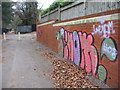
Need more paint
I say, try writing in smaller letters.
Image: © Mr Ignavy
Taken: 1 Jan 2009
0.01 miles
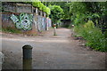
2
Someone leaves their mark
Path by High Wycombe cemetery.
Image: © Mr Ignavy
Taken: 1 Jan 2009
0.01 miles
4
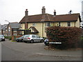
Old house - Shrubbery Close
I suspect the garden of this house was sold off for the new houses in the area.
Image: © Mr Ignavy
Taken: 1 Jan 2009
0.01 miles
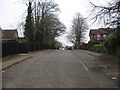
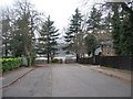
5
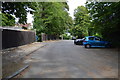
Shrubbery Road
High Wycombe, a grey New Year's morning, 2009.
Image: © Mr Ignavy
Taken: 1 Jan 2009
0.01 miles
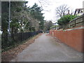
6
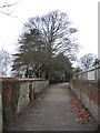
Path between the walls
Running north along the eastern boundary of High Wycombe cemetery. This is just before Shrubbery Road.
Image: © Mr Ignavy
Taken: 1 Jan 2009
0.02 miles
7
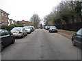
Shrubbery Road
Looking towards the cemetery.
Image: © Mr Ignavy
Taken: 1 Jan 2009
0.02 miles
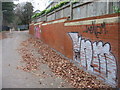
8
Fence and red wall
Path beside High Wycombe cemetery.
Image: © Mr Ignavy
Taken: 1 Jan 2009
0.02 miles