IMAGES TAKEN NEAR TO
Queens Road, HIGH WYCOMBE, HP13 6EG
Introduction
This page details the photographs taken nearby to Queens Road, HP13 6EG by members of the Geograph project.
The Geograph project started in 2005 with the aim of publishing, organising and preserving representative images for every square kilometre of Great Britain, Ireland and the Isle of Man.

There are currently over 7.5m images from over14,400 individuals and you can help contribute to the project by visiting https://www.geograph.org.uk
Image Map
Images are licensed for reuse under creativecommons.org/licenses/by-sa/2.0
Notes
- Clicking on the map will re-center to the selected point.
- The higher the marker number, the further away the image location is from the centre of the postcode.
Image Listing (76 Images Found)
Images are licensed for reuse under creativecommons.org/licenses/by-sa/2.0
Image
Details
Distance
2
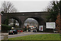
High Wycombe
Railway viaduct, seen beyond the end of Totteridge Avenue, at the junction with Bowerdean Road.
Image: © Peter Trimming
Taken: 23 Mar 2016
0.05 miles
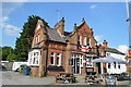
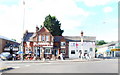
6
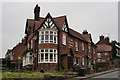
The Gordon Arms
Located close to the centre of High Wycombe, at the junction of Gordon Road and Totteridge Avenue. Closed as of March 2016.
Image: © Peter Trimming
Taken: 23 Mar 2016
0.07 miles
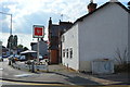
7
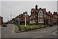
The Gordon Arms
Located close to the centre of High Wycombe, at the junction of Gordon Road and Totteridge Avenue. Closed as of March 2016.
Image: © Peter Trimming
Taken: 23 Mar 2016
0.07 miles