IMAGES TAKEN NEAR TO
Hughenden Avenue, HIGH WYCOMBE, HP13 5SN
Introduction
This page details the photographs taken nearby to Hughenden Avenue, HP13 5SN by members of the Geograph project.
The Geograph project started in 2005 with the aim of publishing, organising and preserving representative images for every square kilometre of Great Britain, Ireland and the Isle of Man.

There are currently over 7.5m images from over14,400 individuals and you can help contribute to the project by visiting https://www.geograph.org.uk
Image Map
Images are licensed for reuse under creativecommons.org/licenses/by-sa/2.0
Notes
- Clicking on the map will re-center to the selected point.
- The higher the marker number, the further away the image location is from the centre of the postcode.
Image Listing (31 Images Found)
Images are licensed for reuse under creativecommons.org/licenses/by-sa/2.0
Image
Details
Distance
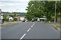
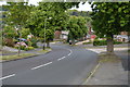
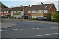
1
Hughenden Avenue south of Fulton Close
Image: © Stuart Logan
Taken: 30 Jul 2014
0.02 miles
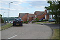
7
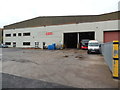
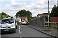
Carousel Bus Depot, High Wycombe
Situated off Hughenden Avenue HP13 5SG, this bus depot houses about 46 vehicles operated by Carousel Buses in High Wycombe and the surrounding area. The red bus behind the van is 503 (OU57 FGX) an ADL Dart 4 of 8.9 metres long with ADL Enviro 29-seater bodywork dating from 2007. Incidentally, ADL stands for Alexander Dennis Limited which is the UK's leading bus and coach manufacturer.
Image: © David Hillas
Taken: 11 Oct 2017
0.12 miles