IMAGES TAKEN NEAR TO
Brands Hill Avenue, HIGH WYCOMBE, HP13 5PU
Introduction
This page details the photographs taken nearby to Brands Hill Avenue, HP13 5PU by members of the Geograph project.
The Geograph project started in 2005 with the aim of publishing, organising and preserving representative images for every square kilometre of Great Britain, Ireland and the Isle of Man.

There are currently over 7.5m images from over14,400 individuals and you can help contribute to the project by visiting https://www.geograph.org.uk
Image Map (Loading...)


Getting Data...Please wait
Leaflet Map data © OpenStreetMap
Images are licensed for reuse under creativecommons.org/licenses/by-sa/2.0
Notes
- Clicking on the map will re-center to the selected point.
- The higher the marker number, the further away the image location is from the centre of the postcode.
Image Listing (6 Images Found)
Images are licensed for reuse under creativecommons.org/licenses/by-sa/2.0
Image
Details
Distance
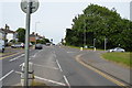
1
Buckinghamshire Chilterns University College
Wellesbourne Campus
Image: © Andrew Smith
Taken: 2 Apr 2006
0.10 miles
2
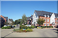
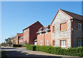
Kingshill Drive, Hazlemere
Another recently completed housing development on the edge of High Wycombe.
Image: © Des Blenkinsopp
Taken: 18 Sep 2019
0.12 miles
3
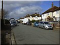
Chadwick Street, High Wycombe
Suburban houses at the junction with Tower Street.
Image: © Andrew Smith
Taken: 5 Mar 2017
0.16 miles
4
Bricked-up window on a new house
What's that all about? Is it supposed to look good? Did the builders forget to order enough window frames? Has the council just reinvented the window tax?
All very strange. New housing at Hazlemere.
Image: © Des Blenkinsopp
Taken: 18 Sep 2019
0.17 miles
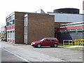
5
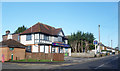
Vets in the Pub
Former pub now the Vets4Pets veterinary surgery.
Image: © Des Blenkinsopp
Taken: 25 Jan 2018
0.21 miles