IMAGES TAKEN NEAR TO
Flitcroft Lea, HIGH WYCOMBE, HP13 5LE
Introduction
This page details the photographs taken nearby to Flitcroft Lea, HP13 5LE by members of the Geograph project.
The Geograph project started in 2005 with the aim of publishing, organising and preserving representative images for every square kilometre of Great Britain, Ireland and the Isle of Man.

There are currently over 7.5m images from over14,400 individuals and you can help contribute to the project by visiting https://www.geograph.org.uk
Image Map (Loading...)


Getting Data...Please wait
Leaflet Map data © OpenStreetMap
Images are licensed for reuse under creativecommons.org/licenses/by-sa/2.0
Notes
- Clicking on the map will re-center to the selected point.
- The higher the marker number, the further away the image location is from the centre of the postcode.
Image Listing (72 Images Found)
Images are licensed for reuse under creativecommons.org/licenses/by-sa/2.0
Image
Details
Distance
5
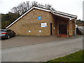
Kingdom Hall of Jehovah's Witnesses, High Wycombe
Situated in Bellfield Road HP13 5HP, this Kingdom Hall has midweek meetings on Wednesdays and Thursdays at 7.15pm, and weekend meetings on Sundays at 10.00am and 2.00pm. The blue "jw.org" notice on the building refers to their website.
Image: © David Hillas
Taken: 16 Mar 2017
0.08 miles
7
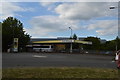
High Wycombe : Morrisons Petrol Station
From the petrol pump.
Image: © Lewis Clarke
Taken: 9 Oct 2016
0.10 miles
8
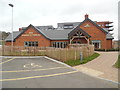
The Spindle & Thread Pub, High Wycombe (1)
Situated in Bellfield Road HP13 5HP, this pub is named in honour of High Wycombe's history as a mill town. The river Wye that runs through that town was used to power mills from the 11th century and, over the years, these mills have produced everything from woven cloth to paper. Lace manufacturing became a huge part of the town's economy in the 17th century and remained as such until the 19th century. To reflect this, the name "Spindle and Thread" was chosen.
Image: © David Hillas
Taken: 20 Feb 2019
0.10 miles
10
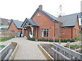
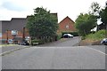
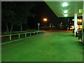
The Spindle & Thread Pub, High Wycombe (2)
This photo shows the entrance to this pub in Bellfield Road with the wooden bridge in the foreground crossing over a stream. It was opened in the 2010s and offers food and drink daily. In the background on the hill to the extreme left of the photo are houses and apartments in Gandon Vale, which were built to meet an increasing need for housing in High Wycombe.
Image: © David Hillas
Taken: 20 Feb 2019
0.11 miles