IMAGES TAKEN NEAR TO
Southfield Road, HIGH WYCOMBE, HP13 5JZ
Introduction
This page details the photographs taken nearby to Southfield Road, HP13 5JZ by members of the Geograph project.
The Geograph project started in 2005 with the aim of publishing, organising and preserving representative images for every square kilometre of Great Britain, Ireland and the Isle of Man.

There are currently over 7.5m images from over14,400 individuals and you can help contribute to the project by visiting https://www.geograph.org.uk
Image Map
Images are licensed for reuse under creativecommons.org/licenses/by-sa/2.0
Notes
- Clicking on the map will re-center to the selected point.
- The higher the marker number, the further away the image location is from the centre of the postcode.
Image Listing (11 Images Found)
Images are licensed for reuse under creativecommons.org/licenses/by-sa/2.0
Image
Details
Distance
1
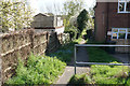
Path to Desborough Recreation Ground
Leaving West Wycombe Road between the houses.
Image: © Bill Boaden
Taken: 20 Apr 2018
0.12 miles
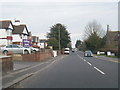
2
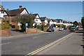
West Wycombe Road
Mature residential properties line this very busy road, part of the A40.
Image: © Bill Boaden
Taken: 20 Apr 2018
0.15 miles
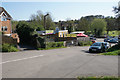
3
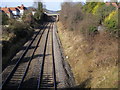
Railway line heading towards Princes Risborough
Railway line heading towards Princes Risborough at Plomer Hill Bridge
Image: © Shaun Ferguson
Taken: 25 Feb 2008
0.16 miles
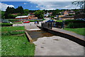
5
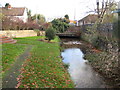
River Wye (Mill Brook) in Wycombe
Up until about the 1900s Wycombe used to have a couple of corn mills in this area, powered by water flowing along this leat, while the main river ran parallel and to the south. The mills are long gone but the word lives on in the road names. This is the leat approaching the Mill End Road bridge.
Image: © Nigel Cox
Taken: 7 Nov 2009
0.21 miles
7
Fryers Lane
An access road to Desborough Recreation Ground. There was a church here as marked on some older maps, but now there is a handily placed children's day nursery.
Image: © Bill Boaden
Taken: 20 Apr 2018
0.22 miles
9
Ford at High Wycombe
This ford is found on the footpath beside the playground in a suburb of High Wycombe.
Image: © John Walton
Taken: 2 Jun 2013
0.25 miles
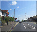
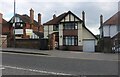
10
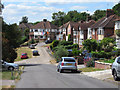
Westover Road, Downley
Houses on the western outskirts of the Wycombe urban area.
Image: © Andrew Smith
Taken: 3 Jul 2010
0.25 miles