IMAGES TAKEN NEAR TO
Talbot Avenue, HIGH WYCOMBE, HP13 5JA
Introduction
This page details the photographs taken nearby to Talbot Avenue, HP13 5JA by members of the Geograph project.
The Geograph project started in 2005 with the aim of publishing, organising and preserving representative images for every square kilometre of Great Britain, Ireland and the Isle of Man.

There are currently over 7.5m images from over14,400 individuals and you can help contribute to the project by visiting https://www.geograph.org.uk
Image Map (Loading...)


Getting Data...Please wait
Leaflet Map data © OpenStreetMap
Images are licensed for reuse under creativecommons.org/licenses/by-sa/2.0
Notes
- Clicking on the map will re-center to the selected point.
- The higher the marker number, the further away the image location is from the centre of the postcode.
Image Listing (2 Images Found)
Images are licensed for reuse under creativecommons.org/licenses/by-sa/2.0
Image
Details
Distance
1
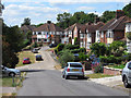
Westover Road, Downley
Houses on the western outskirts of the Wycombe urban area.
Image: © Andrew Smith
Taken: 3 Jul 2010
0.20 miles
2
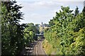
Railway line to Princes Risborough
The view from Plomer Hill railway bridge towards West Wycombe and Princes Risborough. On the hill is the Mausoleum and West Wycombe Church with its golden ball atop the tower.
Image: © Bob Walters
Taken: 19 Aug 2022
0.23 miles