IMAGES TAKEN NEAR TO
Maitland Drive, HIGH WYCOMBE, HP13 5BP
Introduction
This page details the photographs taken nearby to Maitland Drive, HP13 5BP by members of the Geograph project.
The Geograph project started in 2005 with the aim of publishing, organising and preserving representative images for every square kilometre of Great Britain, Ireland and the Isle of Man.

There are currently over 7.5m images from over14,400 individuals and you can help contribute to the project by visiting https://www.geograph.org.uk
Image Map
Images are licensed for reuse under creativecommons.org/licenses/by-sa/2.0
Notes
- Clicking on the map will re-center to the selected point.
- The higher the marker number, the further away the image location is from the centre of the postcode.
Image Listing (34 Images Found)
Images are licensed for reuse under creativecommons.org/licenses/by-sa/2.0
Image
Details
Distance
1
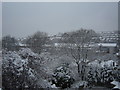
Snowy treetops
View across the disused Broomwade building, with The Pastures estate & Hughenden Avenue/Telford Way behind.
Image: © Giles Devlin
Taken: 8 Feb 2007
0.13 miles
2
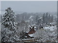
Snowy treetops
A view across Hughenden Road rooftops to Hughenden Park, towards the Manor.
Image: © Giles Devlin
Taken: 8 Feb 2007
0.13 miles
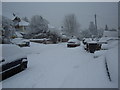
6
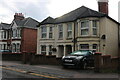
Houses on Hughenden Road, High Wycombe
Image: © David Howard
Taken: 27 Sep 2022
0.15 miles
9
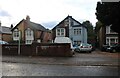
Houses on Hughenden Road, High Wycombe
Image: © David Howard
Taken: 27 Sep 2022
0.17 miles
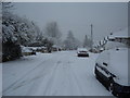
10
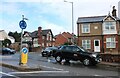
Hughenden Road at the junction of Hamilton Road
Image: © David Howard
Taken: 27 Sep 2022
0.17 miles