IMAGES TAKEN NEAR TO
Rowcroft, HEMEL HEMPSTEAD, HP1 2JF
Introduction
This page details the photographs taken nearby to Rowcroft, HP1 2JF by members of the Geograph project.
The Geograph project started in 2005 with the aim of publishing, organising and preserving representative images for every square kilometre of Great Britain, Ireland and the Isle of Man.

There are currently over 7.5m images from over14,400 individuals and you can help contribute to the project by visiting https://www.geograph.org.uk
Image Map
Images are licensed for reuse under creativecommons.org/licenses/by-sa/2.0
Notes
- Clicking on the map will re-center to the selected point.
- The higher the marker number, the further away the image location is from the centre of the postcode.
Image Listing (20 Images Found)
Images are licensed for reuse under creativecommons.org/licenses/by-sa/2.0
Image
Details
Distance
5
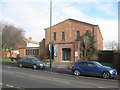
Hemel Hempstead: St George's United Reformed Church
This church is on Long Chaulden.
Image: © Nigel Cox
Taken: 1 Feb 2015
0.16 miles
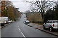
6
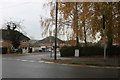
Long Chaulden at the junction of Lindlings
Image: © David Howard
Taken: 23 Nov 2019
0.18 miles
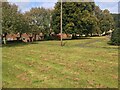
7
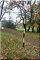
Yellow striped pole on Shrub Hill Common
These stopped being made in 1964, and normally only for parking regulations. I have never come across one remaining in such good condition.
Image: © David Howard
Taken: 23 Nov 2019
0.18 miles
8
Shrub Hill Common by Long Chaulden
The striped pole is the best known remaining example in the country, having been only used for parking signs and a few others, nearly all others having been painted over and only visible when it began to wear off. I have not found another either uncovered or in this condition before. This is an example of the usual types left over. https://www.geograph.org.uk/photo/2272327
Image: © David Howard
Taken: 23 Nov 2019
0.18 miles
9
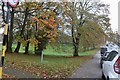
Long Chaulden, Hemel Hempstead
Going through Shrub Hill Common
Image: © David Howard
Taken: 23 Nov 2019
0.19 miles
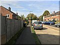
10
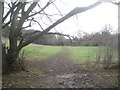
Hemel Hempstead: Shrub Hill Common dry valley (2)
Shrub Hill Common is a gently undulating part-wooded chalk dry valley, and, unlike much of the surrounding area, has remained undeveloped for residential housing. This path runs along the bottom of the valley.
Image: © Nigel Cox
Taken: 1 Feb 2015
0.19 miles