IMAGES TAKEN NEAR TO
Musk Hill, HEMEL HEMPSTEAD, HP1 2JB
Introduction
This page details the photographs taken nearby to Musk Hill, HP1 2JB by members of the Geograph project.
The Geograph project started in 2005 with the aim of publishing, organising and preserving representative images for every square kilometre of Great Britain, Ireland and the Isle of Man.

There are currently over 7.5m images from over14,400 individuals and you can help contribute to the project by visiting https://www.geograph.org.uk
Image Map
Images are licensed for reuse under creativecommons.org/licenses/by-sa/2.0
Notes
- Clicking on the map will re-center to the selected point.
- The higher the marker number, the further away the image location is from the centre of the postcode.
Image Listing (11 Images Found)
Images are licensed for reuse under creativecommons.org/licenses/by-sa/2.0
Image
Details
Distance
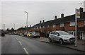
8
Long Chaulden at the junction of Lindlings
Image: © David Howard
Taken: 23 Nov 2019
0.23 miles
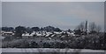
9
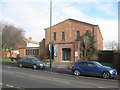
Hemel Hempstead: St George's United Reformed Church
This church is on Long Chaulden.
Image: © Nigel Cox
Taken: 1 Feb 2015
0.23 miles
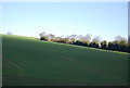
10
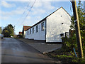
Converted farm building, Pouchen End Farm
Image: © Robin Webster
Taken: 7 Jan 2018
0.24 miles