IMAGES TAKEN NEAR TO
Prince Park, HEMEL HEMPSTEAD, HP1 2AT
Introduction
This page details the photographs taken nearby to Prince Park, HP1 2AT by members of the Geograph project.
The Geograph project started in 2005 with the aim of publishing, organising and preserving representative images for every square kilometre of Great Britain, Ireland and the Isle of Man.

There are currently over 7.5m images from over14,400 individuals and you can help contribute to the project by visiting https://www.geograph.org.uk
Image Map (5 Images)


Getting Data...Please wait
Leaflet Map data © OpenStreetMap
Images are licensed for reuse under creativecommons.org/licenses/by-sa/2.0
Notes
- Clicking on the map will re-center to the selected point.
- The higher the marker number, the further away the image location is from the centre of the postcode.
Image Listing (5 Images Found)
Images are licensed for reuse under creativecommons.org/licenses/by-sa/2.0
Image
Details
Distance
1
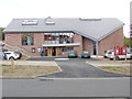
Hemel Hempstead Methodist Church (1)
Situated in Northridge Way, this new Church was officially opened on Saturday 13th June 2015, replacing the former Bourne Methodist Church on the same site. Services take place here every Sunday at 10.30am, with Messy Church being held on the second Sunday of each month at 3.30pm. Activities also take place here during the week.
Image: © David Hillas
Taken: 9 May 2015
0.12 miles
2
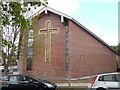
Hemel Hempstead Methodist Church (2)
Taken in Ashtree Way, this photo shows the end part of the rebuilt church with a large cross inscribed in it. This church is one of twentytwo churches in the West Hertfordshire & Borders Methodist Circuit, its postcode being HP1 2AU.
Image: © David Hillas
Taken: 9 May 2015
0.12 miles
4
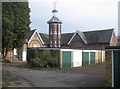
Hemel Hempstead: Chaulden House Tower
Now somewhat incongruously enclosed with lock-up garages this tower and the surrounding stable block are all that remains of the former Chaulden House. The purposes of the tower appear to have been multiple. It was evidently a dovecote but there is evidence online to suggest that it was the residence's water tower. It is a Grade II Listed structure and the English Heritage website described it thus:-
"Mid C19 octagonal tower. Flint rubble, red brick quoins and semi-cylindrical angle mouldings. Pyramidal Welsh slated roof with eaves cornice on console angle brackets. Octagonal wooden lantern with colonnettes, weather vane. Pointed arches to doorway, slit windows and dummy windows. Conch shells set in flint rubble above arches, Pointed arched pigeon holes above windows on 3 sides in 3 rows, lowest 3 light, central 2 light, upper 1 light under conch shell. Continuous band of shells below brick frieze. Included as a curiosity."
The stable block is currently in use by the NHS as the Isbister Centre.
Image: © Nigel Cox
Taken: 1 Feb 2015
0.23 miles
5

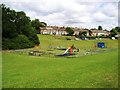
Long Chaulden at the junction of Pixies Hill Road
Image: © David Howard
Taken: 23 Nov 2019
0.25 miles