IMAGES TAKEN NEAR TO
Pine Chase, HIGH WYCOMBE, HP12 4UG
Introduction
This page details the photographs taken nearby to Pine Chase, HP12 4UG by members of the Geograph project.
The Geograph project started in 2005 with the aim of publishing, organising and preserving representative images for every square kilometre of Great Britain, Ireland and the Isle of Man.

There are currently over 7.5m images from over14,400 individuals and you can help contribute to the project by visiting https://www.geograph.org.uk
Image Map
Images are licensed for reuse under creativecommons.org/licenses/by-sa/2.0
Notes
- Clicking on the map will re-center to the selected point.
- The higher the marker number, the further away the image location is from the centre of the postcode.
Image Listing (4 Images Found)
Images are licensed for reuse under creativecommons.org/licenses/by-sa/2.0
Image
Details
Distance
2
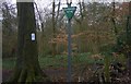
Old Footpath Sign onto Booker Common
Very old public footpath sign onto Booker Common. The paths do get complicated in this small common. This route is on London Green Belt Way long distance path.
Image: © Sean Davis
Taken: 13 Mar 2011
0.23 miles
3
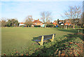
Seat on Booker Common
Most of Booker Common is woodland.
At the southern end, a small area is cleared and is more of a local park.
Image: © Des Blenkinsopp
Taken: 17 Jan 2017
0.23 miles
4
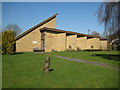
High Wycombe: Church of St Birinus and St John
This new church, in the Booker area of High Wycombe, is one of a small select group dedicated to St Birinus. St Birinus was the first Bishop of Dorchester and known as the Apostle to the West Saxons. He died in 649 and his feast day is 4 September. The church is on Sycamore Road off Cressex Road, and its website is here http://www.banjos.org.uk/
Update September 2020
It is evident from StreetView that this Church had already been demolished by May 2012, and a new church, now of Christ the Servant King, was being constructed on the site.
Image: © Nigel Cox
Taken: 19 Mar 2011
0.25 miles