IMAGES TAKEN NEAR TO
Highwood Crescent, HIGH WYCOMBE, HP12 4NA
Introduction
This page details the photographs taken nearby to Highwood Crescent, HP12 4NA by members of the Geograph project.
The Geograph project started in 2005 with the aim of publishing, organising and preserving representative images for every square kilometre of Great Britain, Ireland and the Isle of Man.

There are currently over 7.5m images from over14,400 individuals and you can help contribute to the project by visiting https://www.geograph.org.uk
Image Map
Images are licensed for reuse under creativecommons.org/licenses/by-sa/2.0
Notes
- Clicking on the map will re-center to the selected point.
- The higher the marker number, the further away the image location is from the centre of the postcode.
Image Listing (15 Images Found)
Images are licensed for reuse under creativecommons.org/licenses/by-sa/2.0
Image
Details
Distance
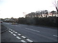
1
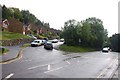
The junction of Lane End Road and Warwick Avenue
Image: © Steve Daniels
Taken: 21 Aug 2010
0.14 miles
3
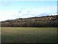
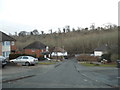
The western edge of High Wycombe
Arundel Road and Highwood Avenue run across the hillside.
Image: © Andrew Smith
Taken: 31 Dec 2005
0.18 miles
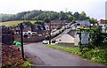
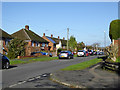
8
Booker Hill Road, High Wycombe
At the Field Road bus stop.
Image: © Des Blenkinsopp
Taken: 2 May 2017
0.20 miles
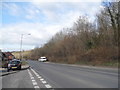
10
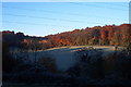
Winter view from my house in Carisbrooke Avenue, Sands. High Wycombe, Bucks. HP12 4NL
Winter View From my house in Carisbrooke Avenue Sands.
High Wycombe Bucks. HP12 4NL
Image: © malcolm jacks
Taken: 1 Jan 2001
0.21 miles