IMAGES TAKEN NEAR TO
West Wycombe Road, HIGH WYCOMBE, HP12 4AA
Introduction
This page details the photographs taken nearby to West Wycombe Road, HP12 4AA by members of the Geograph project.
The Geograph project started in 2005 with the aim of publishing, organising and preserving representative images for every square kilometre of Great Britain, Ireland and the Isle of Man.

There are currently over 7.5m images from over14,400 individuals and you can help contribute to the project by visiting https://www.geograph.org.uk
Image Map (Loading...)


Getting Data...Please wait
Leaflet Map data © OpenStreetMap
Images are licensed for reuse under creativecommons.org/licenses/by-sa/2.0
Notes
- Clicking on the map will re-center to the selected point.
- The higher the marker number, the further away the image location is from the centre of the postcode.
Image Listing (16 Images Found)
Images are licensed for reuse under creativecommons.org/licenses/by-sa/2.0
Image
Details
Distance
2
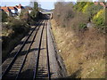
Railway line heading towards Princes Risborough
Railway line heading towards Princes Risborough at Plomer Hill Bridge
Image: © Shaun Ferguson
Taken: 25 Feb 2008
0.04 miles
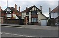
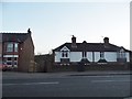
4
Chapel Lane at the junction of West Wycombe Road
Image: © David Howard
Taken: 20 Mar 2016
0.08 miles
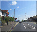
5
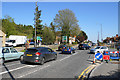
West Wycombe Road
Seen at its junction with Chapel Lane.
Image: © Bill Boaden
Taken: 20 Apr 2018
0.08 miles
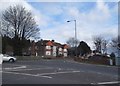
6
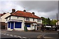
Chapel Express on the corner of Chapel Lane and Gilletts Lane
Image: © Steve Daniels
Taken: 21 Aug 2010
0.09 miles
7
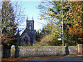
Chapel House,West Wycombe
Just looking like a church, apparently it always was a house. In the West Wycombe Park grounds, from about 1800, a grade II listed building in a grade I listed park.
Image: © Robin Webster
Taken: 23 Nov 2017
0.12 miles
10
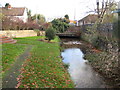
River Wye (Mill Brook) in Wycombe
Up until about the 1900s Wycombe used to have a couple of corn mills in this area, powered by water flowing along this leat, while the main river ran parallel and to the south. The mills are long gone but the word lives on in the road names. This is the leat approaching the Mill End Road bridge.
Image: © Nigel Cox
Taken: 7 Nov 2009
0.14 miles