IMAGES TAKEN NEAR TO
Halifax Road, HIGH WYCOMBE, HP12 3SE
Introduction
This page details the photographs taken nearby to Halifax Road, HP12 3SE by members of the Geograph project.
The Geograph project started in 2005 with the aim of publishing, organising and preserving representative images for every square kilometre of Great Britain, Ireland and the Isle of Man.

There are currently over 7.5m images from over14,400 individuals and you can help contribute to the project by visiting https://www.geograph.org.uk
Image Map
Images are licensed for reuse under creativecommons.org/licenses/by-sa/2.0
Notes
- Clicking on the map will re-center to the selected point.
- The higher the marker number, the further away the image location is from the centre of the postcode.
Image Listing (15 Images Found)
Images are licensed for reuse under creativecommons.org/licenses/by-sa/2.0
Image
Details
Distance
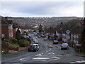
1
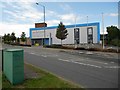
High Wycombe: Halifax House on the Cressex Industrial Estate
The road is Coronation Road so named presumably after the Coronation of Queen Elizabeth II in 1953.
Image: © Nigel Cox
Taken: 25 Jul 2015
0.01 miles
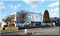
2
Halifax Road
Halifax Road on Cressex Industrial Estate
Image: © Shaun Ferguson
Taken: 7 Mar 2008
0.03 miles
3
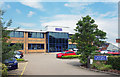
Oxford Instruments, Halifax Road
One of the units on the Cressex Business Estate, Oxford Instruments is a leading provider of high technology tools and systems for research and industry.
Image: © Des Blenkinsopp
Taken: 31 May 2018
0.06 miles
4
Cressex Industrial Estate
Coronation Road looking north.
Image: © Ray Stanton
Taken: 17 Jul 2006
0.07 miles
6
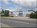
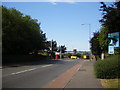
High Wycombe: Jewson builders' merchants
Jewson claim to be the UK's leading chain of builders' merchants with over 600 branches nationwide. This branch is on Coronation Road on the Cressex Industrial Estate.
Image: © Nigel Cox
Taken: 25 Jul 2015
0.14 miles
7
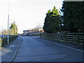
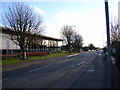
Chairborough Road, High Wycombe
Looking north along the road which descends one of the Wycombe valleys.
Image: © Andrew Smith
Taken: 2 Apr 2006
0.19 miles
8
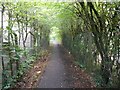
High Wycombe: Footpath in Cressex (2)
The hilly ground south of High Wycombe was criss-crossed with several public footpaths long before the houses and factories arrived. However when they were built the old footpath routes were kept and this is one running between the houses on New Road and heading towards the industrial estate on Halifax Road.
Image: © Nigel Cox
Taken: 25 Jul 2015
0.20 miles
9
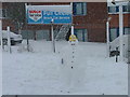
Snow(work)man in Cressex Business Park
Image: © Peter Jemmett
Taken: 8 Feb 2007
0.21 miles
10
The Lord Rank Centre
More boldly badged as the Hovis bakery, The Lord Rank Centre is in smaller print under the loaf logo over the entrance.
Lord Rank, of Rank Hovis McDougall flour fame, is probably better known as J. Arthur Rank of the Rank Organisation, film and cinema mogul.
Lots about him, recounting his journey from flour to films via Methodism, on https://en.wikipedia.org/wiki/J._Arthur_Rank
Image: © Des Blenkinsopp
Taken: 4 Feb 2017
0.22 miles