IMAGES TAKEN NEAR TO
Carrington Road, HIGH WYCOMBE, HP12 3JB
Introduction
This page details the photographs taken nearby to Carrington Road, HP12 3JB by members of the Geograph project.
The Geograph project started in 2005 with the aim of publishing, organising and preserving representative images for every square kilometre of Great Britain, Ireland and the Isle of Man.

There are currently over 7.5m images from over14,400 individuals and you can help contribute to the project by visiting https://www.geograph.org.uk
Image Map
Images are licensed for reuse under creativecommons.org/licenses/by-sa/2.0
Notes
- Clicking on the map will re-center to the selected point.
- The higher the marker number, the further away the image location is from the centre of the postcode.
Image Listing (11 Images Found)
Images are licensed for reuse under creativecommons.org/licenses/by-sa/2.0
Image
Details
Distance
1
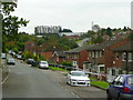
Carrington Road, High Wycombe
A long cul-de-sac of 1960's housing.
Nice car!
Image: © Jonathan Billinger
Taken: 30 Sep 2008
0.08 miles
2
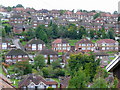
Suburban High Wycombe
Looking west from Carrington Road across at least six parallel rows of houses.
Image: © Jonathan Billinger
Taken: 30 Sep 2008
0.12 miles
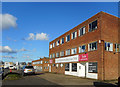
3
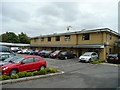
Business units at Cressex Business Park
Small workshop and retail units to the south of High Wycombe.
Image: © Jonathan Billinger
Taken: 30 Sep 2008
0.17 miles
4
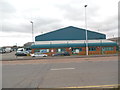
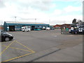
Arriva Bus Depot, High Wycombe (1)
Situated in Lincoln Road, Cressex HP12 3RH, this bus depot was opened in October 2005 replacing the former depot at Newlands Bus Station in High Wycombe town centre. The offices with the workshop behind them can be seen in this photo, they being painted in Arriva's turquoise livery. The parking area for buses and other vehicles is to the left of the photo.
Image: © David Hillas
Taken: 2 Feb 2018
0.22 miles
5
Evans Furniture Factory
Furniture makers since 1958, as it says on the front. Their showroom is a short way down the road.
High Wycombe has long been associated with the furniture trade, a traditional Chiltern industry.
Image: © Des Blenkinsopp
Taken: 4 Feb 2017
0.22 miles
6
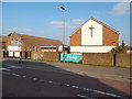
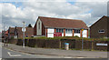
The Avenue Methodist Church, Castlefield (1)
Situated in Rutland Avenue, HP12 3JQ, this dates from 1953 and is one of ten Methodist Churches in the High Wycombe Circuit. The church itself is on the right with a cross on its front, whilst the church hall can be seen to the left of the photo.
Image: © David Hillas
Taken: 28 Mar 2019
0.23 miles
7
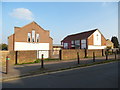
The Avenue Methodist Church, Castlefield (2)
This photo shows the Methodist Church in Rutland Avenue with the dark red noticeboard in front of it. It was officially opened on Saturday 5th September 1953, and services take place here each Sunday at 10.30am with activities being held during the week.
Image: © David Hillas
Taken: 28 Mar 2019
0.23 miles
8
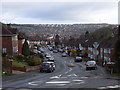
Chairborough Road, High Wycombe
Looking north along the road which descends one of the Wycombe valleys.
Image: © Andrew Smith
Taken: 2 Apr 2006
0.23 miles
9
The Avenue Methodist Church
On Rutland Avenue.
Image: © Des Blenkinsopp
Taken: 2 May 2017
0.23 miles
10
Arriva Bus Depot, High Wycombe (2)
Taken from Shackleton Road, this photo shows the entrance to the bus workshops and the parking area in front of it. Just over 50 buses are based here running on routes in and out of High Wycombe. Also, M & M Coaches, which is a coach hire company, have vehicles based here.
Image: © David Hillas
Taken: 2 Feb 2018
0.24 miles