IMAGES TAKEN NEAR TO
The Cornfields, HEMEL HEMPSTEAD, HP1 1UB
Introduction
This page details the photographs taken nearby to The Cornfields, HP1 1UB by members of the Geograph project.
The Geograph project started in 2005 with the aim of publishing, organising and preserving representative images for every square kilometre of Great Britain, Ireland and the Isle of Man.

There are currently over 7.5m images from over14,400 individuals and you can help contribute to the project by visiting https://www.geograph.org.uk
Image Map
Images are licensed for reuse under creativecommons.org/licenses/by-sa/2.0
Notes
- Clicking on the map will re-center to the selected point.
- The higher the marker number, the further away the image location is from the centre of the postcode.
Image Listing (37 Images Found)
Images are licensed for reuse under creativecommons.org/licenses/by-sa/2.0
Image
Details
Distance
1
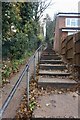
Steps from Beechfield Road to Hanger Close
Image: © David Howard
Taken: 23 Nov 2019
0.06 miles
2
Twin striped poles on Beechfield Road, Boxmoor
It is unusual to have adjacent signs on separate poles, they usually share one, plus they have allowed them to keep their pre-1964 stripes.
Image: © David Howard
Taken: 23 Nov 2019
0.06 miles
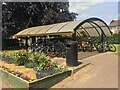
3
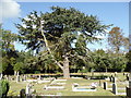
Heath Lane Cemetery
The well kept Heath Lane Cemetery
Image: © Shaun Ferguson
Taken: 30 Apr 2010
0.09 miles
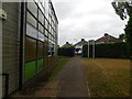
6
Old Drama Block, The Hemel Hempstead School
Image: © Bryn Holmes
Taken: 22 Jun 2017
0.10 miles
7
Chemistry Block, The Hemel Hempstead School
Image: © Bryn Holmes
Taken: 22 Jun 2017
0.10 miles
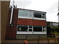
8
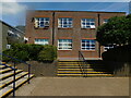
Sixth Form Block, The Hemel Hempstead School
Image: © Bryn Holmes
Taken: 7 Jul 2017
0.10 miles
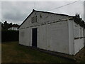
9

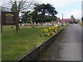
Chapel in South Hill Cemetery
One of two chapels in the cemetery.
Image: © Geoff Harris
Taken: 12 Oct 2009
0.11 miles