IMAGES TAKEN NEAR TO
Anchor Lane, HEMEL HEMPSTEAD, HP1 1NX
Introduction
This page details the photographs taken nearby to Anchor Lane, HP1 1NX by members of the Geograph project.
The Geograph project started in 2005 with the aim of publishing, organising and preserving representative images for every square kilometre of Great Britain, Ireland and the Isle of Man.

There are currently over 7.5m images from over14,400 individuals and you can help contribute to the project by visiting https://www.geograph.org.uk
Image Map
Images are licensed for reuse under creativecommons.org/licenses/by-sa/2.0
Notes
- Clicking on the map will re-center to the selected point.
- The higher the marker number, the further away the image location is from the centre of the postcode.
Image Listing (61 Images Found)
Images are licensed for reuse under creativecommons.org/licenses/by-sa/2.0
Image
Details
Distance
2
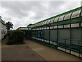
New Drama Block, The Hemel Hempstead School
Image: © Bryn Holmes
Taken: 22 Jun 2017
0.13 miles
4
Technology Block, The Hemel Hempstead School
Image: © Bryn Holmes
Taken: 22 Jun 2017
0.15 miles
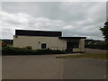
5

Food Technology Block, The Hemel Hempstead School
Image: © Bryn Holmes
Taken: 7 Jul 2017
0.16 miles
6
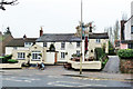
The Steam Coach, Hemel Hempstead
Purists may say this is Boxmoor - whatever, it is on St. John's Road.
Image: © Robin Webster
Taken: 16 Nov 2014
0.16 miles
7
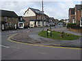
Anchor Lane
Anchor Lane junction with St Johns Road
Image: © Shaun Ferguson
Taken: 30 Apr 2010
0.16 miles
9
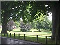
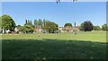
Green space in Boxmoor, Hemel Hempstead
This open space reaches down to the canal and river.
Image: © Jack Hill
Taken: 25 Aug 2005
0.16 miles