IMAGES TAKEN NEAR TO
The Bury, HEMEL HEMPSTEAD, HP1 1HR
Introduction
This page details the photographs taken nearby to The Bury, HP1 1HR by members of the Geograph project.
The Geograph project started in 2005 with the aim of publishing, organising and preserving representative images for every square kilometre of Great Britain, Ireland and the Isle of Man.

There are currently over 7.5m images from over14,400 individuals and you can help contribute to the project by visiting https://www.geograph.org.uk
Image Map
Images are licensed for reuse under creativecommons.org/licenses/by-sa/2.0
Notes
- Clicking on the map will re-center to the selected point.
- The higher the marker number, the further away the image location is from the centre of the postcode.
Image Listing (80 Images Found)
Images are licensed for reuse under creativecommons.org/licenses/by-sa/2.0
Image
Details
Distance
3
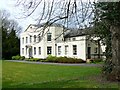
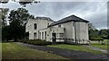
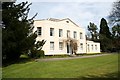
Dacorum Register Office, the Bury, Hemel Hempstead
This fine late 18th century house is now the office for the registration of births, marriages and deaths for Dacorum Borough. It is listed Grade II* http://www.imagesofengland.org.uk/Details/Default.aspx?id=433615
Image: © Brian Robert Marshall
Taken: 16 Apr 2013
0.01 miles
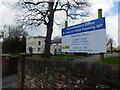
4
The Bury Registry Office
Hemel Hempstead Register Office
Image: © Richard Croft
Taken: 26 Apr 2008
0.02 miles
5

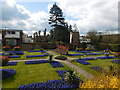
Trees outside Centre in the Park, Gadebridge Park
Image: © Bryn Holmes
Taken: 12 Apr 2021
0.03 miles
6
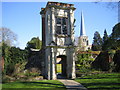
Hemel Hempstead: The Charter Tower
The Charter Tower is so named because local legend has it that Henry VIII stayed with Anne Boleyn in Hemel in 1539, and handed down Hemel Hempstead's market Royal Charter from the upper window, as a mark of gratitude for the hospitality he had received. However the tower was originally the entrance into Bury House which was rebuilt by Sir Richard Combes (or Combe or Coombe or any other similar name depending on what you read!) and his family between 1540 and 1595, so the story is probably mythical. Through the tower there is a glimpse of the Walled Garden, which is the site of the original Bury House, while the spire of St Mary's Church Image is in the background.
Image: © Nigel Cox
Taken: 19 Apr 2007
0.04 miles
7

The Bury footbridge
Footbridge in the grounds of The Bury Register Office
Image: © Richard Croft
Taken: 26 Apr 2008
0.04 miles
8
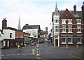
Hemel Hempstead: High Street
This is the southern end of the High Street viewed looking across Queensway from Alexandra Road, with the landmarks, from left to right, of the steeple of St Mary's Church, the tower of the old Town Hall, and the Victorian Gothic steeple of the corner building currently used by ALH Insurance.
The 1940s Ordnance Survey map shows this road junction to be the most important in Hemel with the A4146 road heading south to the left and the A4147 road heading east leaving the junction to go up Alexandra Road towards Hemel Hempstead Midland railway station.
Image: © Nigel Cox
Taken: 14 Oct 2007
0.04 miles
9
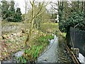
Downstream, River Gade, The Bury, Hemel Hempstead
The small river runs almost entirely within Hertfordshire. Like all the best rivers it is impossible to get a boat on it if you don't count the stretches where it has been incorporated into the Grand Union Canal. More on wikipedia http://en.wikipedia.org/wiki/River_Gade
Image: © Brian Robert Marshall
Taken: 16 Apr 2013
0.05 miles