IMAGES TAKEN NEAR TO
Oakridge Road, HIGH WYCOMBE, HP11 2PE
Introduction
This page details the photographs taken nearby to Oakridge Road, HP11 2PE by members of the Geograph project.
The Geograph project started in 2005 with the aim of publishing, organising and preserving representative images for every square kilometre of Great Britain, Ireland and the Isle of Man.

There are currently over 7.5m images from over14,400 individuals and you can help contribute to the project by visiting https://www.geograph.org.uk
Image Map
Images are licensed for reuse under creativecommons.org/licenses/by-sa/2.0
Notes
- Clicking on the map will re-center to the selected point.
- The higher the marker number, the further away the image location is from the centre of the postcode.
Image Listing (20 Images Found)
Images are licensed for reuse under creativecommons.org/licenses/by-sa/2.0
Image
Details
Distance
1
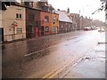
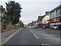
Victorian Cottages on West Wycombe Road
During heavy rain in late July 2007, when parts of England were flooded.
Image: © Ian Mulder
Taken: 26 Jul 2007
0.02 miles
4
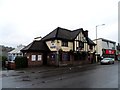
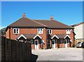
House refurbishment on West Wycombe Road
The housing rises steadily up the hillside behind.
Image: © Bill Boaden
Taken: 20 Apr 2018
0.04 miles
6
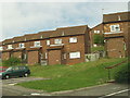
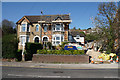
Cumbrian Way, High Wycombe
Part of a modern estate, close to central Wycombe. This is a densely populated area on the southern facing slope of the Wycombe valley.
Image: © Craig
Taken: 4 Sep 2006
0.08 miles
8
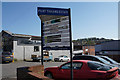
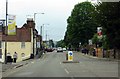
Pilot Trading Estate
A commercial area off West Wycombe Road.
Image: © Bill Boaden
Taken: 20 Apr 2018
0.13 miles
9
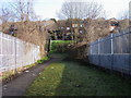
Footpath over the railways bridge
Footpath over the railway bridge up to Cotswold Way.
Image: © Shaun Ferguson
Taken: 25 Feb 2008
0.14 miles
10
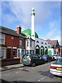
The mosque, High Wycombe
In Jubilee Road next to Oakridge Baptist church.
Image: © Andrew Smith
Taken: 2 Apr 2006
0.14 miles